St George in the East (parish)
| St George in the East St George Middlesex | |
|---|---|
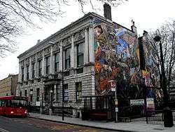 St George's Town Hall | |
 | |
| Area | |
| • 1881 | 243 acres (0.98 km2) |
| Population | |
| • 1881 | 47,157 |
| Density | |
| • 1881 | 194/acre |
| History | |
| • Origin | Split from Stepney parish |
| • Created | 1729 |
| • Abolished | 1927 |
| • Succeeded by | Stepney Borough parish |
| Status | Civil parish |
| Government |
Vestry of the Parish of St George (1855—1900) |
| • HQ | St George's Town Hall, Cable Street |
St George in the East was a parish in the metropolitan area of London, England.
History
The parish was largely rural at the time of its creation, the main settlement a hamlet known as Wapping Stepney.[1] The parish church of St George in the East was completed in 1729 by the Commission for Building Fifty New Churches.
Governance
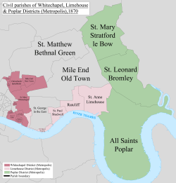
It was part of the ancient parish of Stepney in the Tower division of the Ossulstone hundred of Middlesex. It was split off as a separate parish in 1729.[2] Following the Poor Law Amendment Act 1834, it was a single parish for Poor Law purposes.
The parish vestry became a local authority in the Metropolis in 1855, nominating one member to the Metropolitan Board of Works. Under the Metropolis Management Act 1855 any parish that exceeded 2,000 ratepayers was to be divided into wards; as such the incorporated vestry of St George in the East was divided into two wards (electing vestrymen): No. 1 or North (18) and No. 2 or South (18).[3]
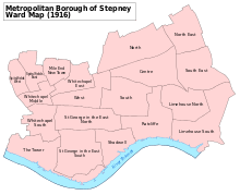
The board of works was replaced by the directly elected London County Council in 1889 and its area of responsibly became the County of London. St George in the East became part of the Metropolitan Borough of Stepney in 1900 and was abolished as a civil parish in 1927. The vestry hall was located on Cable Street and is still in existence.
It was initially part of the Middlesex Parliament constituency and then the Tower Hamlets constituency from 1832 to 1885. A St George constituency was in existence from 1885 to 1918, and then it became part of Whitechapel and St Georges, until it was abolished as a civil parish in 1927.
Geography
Much of the northern boundary of the parish with Mile End Old Town ran alongside Commercial Road. In the west the boundary with Whitechapel fell just short of Back Church Lane. The parish of Wapping bordered it to the south, with Wapping forming a panhandle in the west, dividing it from St Botolph Without Aldgate. The parish of Shadwell was to the east, and the parishes of Wapping and Shadwell almost met, giving St George in the East only a narrow frontage to the River Thames of 53 feet (16 m).
Shadwell and St George's East railway station on the London and Blackwall was within the parish of St George, as was a large part of the London Docks, which have since been filled in. It included parts of the contemporary districts of Shadwell and Wapping.
Notable residents
- Lottie Collins, musical hall singer
References
- ↑ "St George in the East". british-history.ac.uk. Retrieved 18 October 2015.
- ↑ Youngs, Frederic A, Jr. (1979). Guide to the Local Administrative Units of England, Vol.I: Southern England. London: Royal Historical Society. ISBN 0-901050-67-9.
- ↑ The London Gazette Issue: 21802. 20 October 1855. pp. 3895–3896. Retrieved 8 April 2015.
| Districts |
|  Headquarters at Spring Gardens |
|---|---|---|
| Incorporated vestries | Original vestries (1855)
Later vestries
| |
| Undertakings | ||
| Major works | ||
| Legislation | ||
| People | ||
Coordinates: 51°30′28″N 0°03′45″W / 51.5078°N 0.0626°W