Caer Mote
| Caer Mote | |
|---|---|
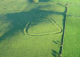
 "The Battery", earthwork on Caer Mote | |
| Highest point | |
| Elevation | 285 m (935 ft) |
| Coordinates | 54°43′38″N 3°14′59″W / 54.7272°N 3.2497°WCoordinates: 54°43′38″N 3°14′59″W / 54.7272°N 3.2497°W |
| Geography | |
| Location | Cumbria, England |
| OS grid | NY196376 |
Caer Mote is a small hill in the north of the English Lake District near Bothel, Cumbria. Its summit at 920 feet (280 m) lies just outside the boundary of the Lake District National Park. It offers a view of Bassenthwaite Lake from its summit, upon which is an ancient earthwork enclosure of undetermined age, known as "The Battery".[1] Under the name Caermote Hill it is the subject of a chapter of Wainwright's book The Outlying Fells of Lakeland.[2] Wainwright's route is an ascent from Bothel via the northern summit St. John's Hill at 935 feet (285 m)[3][4] in an anticlockwise circuit.
There are traces of a 1st-century AD Roman fort to the east of the summit.[5]
References
- ↑ Historic England. "The Battery (9445)". PastScape. Retrieved 4 May 2012.
- ↑ Wainwright, A. (1974). "Caermote Hill". The Outlying Fells of Lakeland. Kendal: Westmorland Gazette. pp. 206–209.
- ↑ St John's Hill is listed in the index to Wainwright's book, but is not mentioned on the first page of the chapter as is his convention for named or nameless summits.
- ↑ "Database of British and Irish Hills". Retrieved 4 May 2012. Source for height of St. John's Hill
- ↑ Historic England. "Caermote Roman Fort (9904)". PastScape. Retrieved 4 May 2012.
This article is issued from Wikipedia - version of the 3/18/2015. The text is available under the Creative Commons Attribution/Share Alike but additional terms may apply for the media files.