St Mary's Church, Cardiff
| St Mary's Church | |
|---|---|
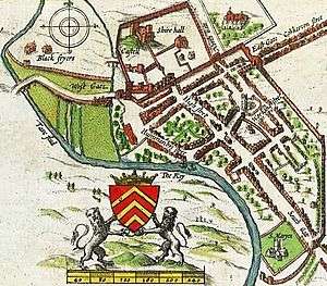 John Speed's 1610 map of Cardiff, showing the southerly location of St Mary's Church, next to the River Taff. | |
| Location | Cardiff |
| Country | Wales |
| Denomination | Anglican |
| History | |
| Founded | 1107 |
| Architecture | |
| Status | Demolished |
| Closed | Abandoned after 1701 |
| Demolished | Ruins demolished after 1701 |
St Mary's Church (Eglwys Fair) was an Anglican church in Cardiff, Wales, which stood at the south end of the current St. Mary's Street, from 1107 until 1620. After severe flood damage it was abandoned in 1701 and later replaced at a different location in 1843.
Early history
St Mary's was founded as a Benedictine priory in the 1080s, by Robert Fitzhamon[1] (also founder of Tewkesbury Abbey in 1092). However, the site next to the River Taff was a poor one, susceptible to both continual flooding and river erosion.[2] Even after stabilising the foundations, bodies from burials would regularly be washed down the river. The abbey withdrew the monks in 1211.[3]
Destruction
In 1607, the area of England and Wales bordering the Bristol Channel experienced a devastating flood, now believed to have been a tsunami.[4] The Bristol Channel floods washed away much of St Mary's foundations[5] and it slowly began to collapse.
In 1620, the decision was made to make St John's the main parish church, which was originally just an offshot development. The two churches were worked as one parish, with all burials and some services continuing at St Mary's.
In 1638, the vicar of St Mary's, William Erbery, was forced to resign, his curate Walter Cradock had his licence revoked, and senior members of the congregation were barred from the premises after they refused to read the Book of Sports. Erbery's other curate, William Wroth, eventually conformed. These people, together with others of a similar mind, formed the core of a congregation, that after the English Civil War and subsequent Restoration, in 1696 were granted land in Womanby Street by Alderman John Archer. This allowed them to build the first Trinity Church, later known as a Presbyterian chapel.[6]
By 1678, with evidence from the visit of Francis Place and later essays from the Celtic scholar Edward Lhuyd, both described St Mary's as being in ruins. The tower collapsed in 1680[2] and the last recorded burial in the churchyard took place in 1698.[3] The last service was held in a roofless ruin in 1701, after which St Mary's was abandoned.[2]
Replacement and later developments
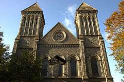
In 1843, John Crichton-Stuart, 2nd Marquess of Bute paid for the construction of the Church of St. Mary the Virgin and St. Stephen the Martyr, in Bute Street as a permanent replacement.[7] The 1843 church was designed by John Foster of Liverpool. The east end (by J. D. Sedding) was added in 1884, later enlarged in 1907. Wall paintings decorate the chancel arch.[8] The church is a Grade II listed building.[9]
The River Taff was diverted in 1850 (by Isambard Kingdom Brunel) to create a site to build the Cardiff Central railway station, also resulting in the creation of Westgate Street.
The Prince of Wales theatre was built on the site of the old church. This is now the location of the current Prince of Wales public house.[3]
See also
References
- ↑ "Cardiff St. Mary". Cardiff. Genuki.org.uk. Retrieved 1 April 2013. Genuki quotes from The Old Parish Churches of Gwent, Glamorgan & Gower (1991), by Mike Salter.
- 1 2 3 "Cardiff city and Bay circular walk". BBC Wales. Retrieved 30 December 2012.
- 1 2 3 "Timeline". Cardiffians.co.uk. Retrieved 31 December 2011.
- ↑ "Anniversary of 1607 killer wave". BBC News. 30 January 2007. Retrieved 8 May 2013.
- ↑ Jenkins, William L. (1854). A History of the Town and Castle of Cardiff. Charles Wakeford. pp. 31–33. Retrieved 8 May 2013.
- ↑ "Trinity Chapel". ancestry.com. Retrieved 30 December 2012.
- ↑ "Bute". peterfinch.co.uk. Retrieved 30 December 2012.
- ↑ "St Mary the Virgin & St Stephen the Martyr Church, Bute Street". Royal Commission on the Ancient and Historical Monuments of Wales. Retrieved 1 April 2013.
- ↑ "Parish Church of St Mary the Virgin and St Stephen the Martyr, including forecourt wall and railings, Butetown". British Listed Buildings. Retrieved 1 April 2013.
External links
Coordinates: 51°28′39″N 3°10′40″W / 51.4775°N 3.1779°W