St Raphael's Estate

Coordinates: 51°33′01″N 0°15′54″W / 51.550411°N 0.26490°W
St Raphael's Estate is a housing estate shared between the Stonebridge and Neasden areas of the London Borough of Brent in northwest London, UK.[1] A community centre is located within the estate on Rainborough Close.[2] It is proposed that 21 new homes will be built on the estate.[1]
Transport
Buses
Two London bus routes terminate at Pifield Way: the 224 and the 232. The 92 terminates at Drury Way (St Raphael's North). Because St Raphael's is very close to Brent Park, there are links to many other bus routes, at IKEA and Tesco, and along the A406 North Circular Road.
Notable residents
- George the Poet - musician
- Raheem Sterling - footballer
Notable organisations
- Sufra - a local charity that is run in the location
References
- 1 2 "New homes at St Raphael's". 17 June 2010. Retrieved 8 July 2010.
- ↑ "St Raphael's Community Centre". Brent Brain. Retrieved 8 July 2010.
| Districts | 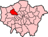 | |
|---|---|---|
| Attractions |
| |
| Parks and open spaces |
| |
| Constituencies | ||
| Tube and rail stations |
| |
| Other topics | ||
This article is issued from Wikipedia - version of the 6/8/2016. The text is available under the Creative Commons Attribution/Share Alike but additional terms may apply for the media files.