Stainby
| Stainby | |
 Stainby hamlet |
|
 Stainby |
|
| OS grid reference | SK908229 |
|---|---|
| – London | 95 mi (153 km) S |
| Civil parish | Gunby and Stainby |
| District | South Kesteven |
| Shire county | Lincolnshire |
| Region | East Midlands |
| Country | England |
| Sovereign state | United Kingdom |
| Post town | GRANTHAM |
| Postcode district | NG33 |
| Police | Lincolnshire |
| Fire | Lincolnshire |
| Ambulance | East Midlands |
| EU Parliament | East Midlands |
| UK Parliament | Grantham and Stamford |
|
|
Coordinates: 52°47′47″N 0°39′14″W / 52.796475°N 0.65391°W
Stainby is a hamlet in the South Kesteven district of Lincolnshire, England. It is situated 2 miles (3.2 km) west from the A1 road, 1.5 miles (2.4 km) east from the Viking Way and the Leicestershire border, and 8 miles (13 km) south from Grantham.
Stainby is nominally in the civil parish of Gunby and Stainby (where the population is included), although the parish is now administered as part of the Colsterworth district parishes.[1] Stainby had been a parish in its own right until 1931.[2] Adjacent villages include Buckminster, North Witham, Colsterworth, Gunby, Sewstern and Skillington.
Stainby is on the A151 road which runs between Melton Mowbray (Buckminster Road) and Colsterworth (Colsterworth Road). The road is frequented by heavy goods vehicles from the nearby industrial estate at Sewstern and by vehicles heading from the Midlands towards East Anglia; an alternative route is through Wymondham and South Witham.[3]
Stainby is recorded in the 1086 Domesday Book as "Stigandebi".[4] The remains of a Motte, probably associated with the former Manor House, stand in the village. It is known as Tower Hill.[3][5][6]
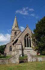
There are no shops or public houses - the nearest are in Colsterworth. The church, on Main Road, is dedicated to St Peter. The former Stainby quarry is an event venue for vehicle off-roading.[7]
References
- ↑ "Colsterworth & District Parishes". Lincolnshire county council. Retrieved 1 June 2013.
Colsterworth and District Parish Council is a combined council consisting of the civil parishes of Colsterworth, (which includes the hamlet of Woolsthorpe By Colsterworth), Gunby and Stainby and recently North Witham, (which includes Lobthorpe).
- ↑ "Stainby CP through time ; Census tables with data for the Parish-level Unit". A Vision of Britain through Time. GB Historical GIS / University of Portsmouth. Retrieved 8 September 2013.
- 1 2 Grantham: Bottesford & Colsterworth (Map) (A1 ed.). 1:25 000. OS Explorer. Ordnance survey of Great Britain. 3 January 2006. § 247. ISBN 9780319238332.
- ↑ Williams, Ann; Martin, G H. Domesday Book: A Complete Translation. London: Penguin. pp. 929; 1403. ISBN 978-0-14-143994-5.
- ↑ Roffe, David. "Former castle on Tower Hill".
- ↑ Historic England. "Tower Hill (325490)". PastScape. Retrieved 2 August 2012.
- ↑ Stainby quarry
External links
England Portal | |
| Unitary authorities | |
| Boroughs or districts | |
| Major settlements |
|
| Topics | |