Stanghelle
| Stanghelle | |
|---|---|
| Village | |
 Stanghelle  Stanghelle Location in Hordaland county | |
| Coordinates: 60°33′08″N 05°44′10″E / 60.55222°N 5.73611°ECoordinates: 60°33′08″N 05°44′10″E / 60.55222°N 5.73611°E | |
| Country | Norway |
| Region | Western Norway |
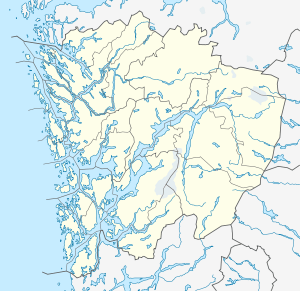
| County | Hordaland |
| District | Nordhordland |
| Municipality | Vaksdal |
| Area[1] | |
| • Total | 0.4 km2 (0.2 sq mi) |
| Elevation[2] | 6 m (20 ft) |
| Population (2013)[1] | |
| • Total | 783 |
| • Density | 1,958/km2 (5,070/sq mi) |
| Time zone | CET (UTC+01:00) |
| • Summer (DST) | CEST (UTC+02:00) |
| Post Code | 5724 Stanghelle |
Stanghelle is a village in Vaksdal municipality in Hordaland county, Norway. The village lies along the Veafjorden at the mouth of the Hellestraumen (a small branch off the main fjord). The 0.4-square-kilometre (99-acre) village has a population (2013) of 783, giving the village a population density of 1,958 inhabitants per square kilometre (5,070/sq mi).[1]
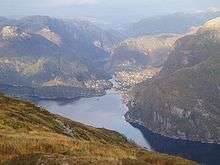
View of Stanghelle, looking northeast
The European route E16 highway runs through the village and the Bergensbanen railway line stops at the Stanghelle Station in this village. The village of Helle lies immediately northeast of Stanghelle, and the municipal centre of Dale lies about 5 kilometres (3.1 mi) northeast of Stanghelle.
References
- 1 2 3 Statistisk sentralbyrå (1 January 2013). "Urban settlements. Population and area, by municipality.".
- ↑ "Stanghelle" (in Norwegian). yr.no. Retrieved 2014-05-02.
This article is issued from Wikipedia - version of the 8/4/2016. The text is available under the Creative Commons Attribution/Share Alike but additional terms may apply for the media files.