Stanley Lake
| Stanley Lake | |
|---|---|
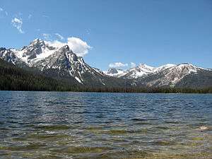 McGown Peak and Stanley Lake | |
| Location | Custer County, Idaho |
| Coordinates | 44°14′39″N 115°03′32″W / 44.2442°N 115.0590°WCoordinates: 44°14′39″N 115°03′32″W / 44.2442°N 115.0590°W |
| Type | Glacial |
| Primary inflows | Stanley Lake Creek |
| Primary outflows | Stanley Lake Creek to Salmon River |
| Basin countries | United States |
| Max. length | 1 mi (1.6 km) |
| Max. width | 0.5 mi (0.80 km) |
| Surface elevation | 6,513 ft (1,985 m) |
Stanley Lake is an alpine lake in Custer County, Idaho, United States, located at the base of the Sawtooth Mountains in the Sawtooth National Recreation Area. The lake is approximately 7 miles (11 km) west of Stanley, readily accessed via a 3 miles (4.8 km) spur road from State Highway 21.[1] The surface elevation of the lake is 6,513 feet (1,985 m) above sea level.
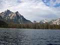
Stanley Lake is northeast of the base of the 9,860 feet (3,010 m) McGown Peak, and just south of the considerably smaller Elk Peak. The lake is 2 miles (3,200 m) downstream of Lady Face Falls on Stanley Lake Creek; it drains into the main Salmon River via Stanley Lake Creek and Valley Creek.
Recreational facilities at the lake include three campgrounds with nightly fees, a day use area, a boat launch, and hiking trails.
 Stanley Lake
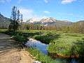 Mountains Behind Stanley Lake
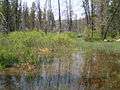 Wetlands Behind Stanley Lake
See also
- List of lakes of the Sawtooth Mountains (Idaho)
- Sawtooth National Forest
- Sawtooth National Recreation Area
- Sawtooth Range (Idaho)
References
- ↑ Sawtooth National Forest. “Sawtooth National Forest” [map].1:126,720, 1”=2 miles. Twin Falls, Idaho: Sawtooth National Forest, United States Forest Service, 1998.
| Wikimedia Commons has media related to Stanley Lake. |
External links
- Public Lands.org - Stanley Lake
- Fishing Works.com - Stanley Lake
- U.S. Forest Service - Sawtooth National Recreation Area