Stargard County
| Stargard County Powiat stargardzki | ||
|---|---|---|
| County | ||
| ||
 Location within the voivodeship | ||
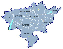 Division into gminas | ||
| Coordinates (Stargard Szczeciński): 53°20′N 15°2′E / 53.333°N 15.033°ECoordinates: 53°20′N 15°2′E / 53.333°N 15.033°E | ||
| Country |
| |
| Voivodeship | West Pomeranian | |
| Seat | Stargard Szczeciński | |
| Gminas | ||
| Area | ||
| • Total | 1,519.59 km2 (586.72 sq mi) | |
| Population (2006) | ||
| • Total | 119,402 | |
| • Density | 79/km2 (200/sq mi) | |
| • Urban | 79,686 | |
| • Rural | 39,716 | |
| Car plates | ZST | |
| Website | http://www.powiatstargardzki.pl | |
Stargard County (Polish: powiat stargardzki) is a unit of territorial administration and local government (powiat) in West Pomeranian Voivodeship, north-western Poland. It came into being on January 1, 1999, as a result of the Polish local government reforms passed in 1998. Its administrative seat and largest town is Stargard Szczeciński, which lies 32 kilometres (20 mi) east of the regional capital Szczecin. The county contains four other towns: Chociwel, 26 km (16 mi) north-east of Stargard Szczeciński, Dobrzany, 27 km (17 mi) east of Stargard Szczeciński, Ińsko, 37 km (23 mi) east of Stargard Szczeciński, and Suchań, 21 km (13 mi) east of Stargard Szczeciński.
The county covers an area of 1,519.59 square kilometres (586.7 sq mi). As of 2006 its total population is 119,402, out of which the population of Stargard Szczeciński is 70,534, that of Chociwel is 3,285, that of Dobrzany is 2,420, that of Ińsko is 2,001, that of Suchań is 1,446, and the rural population is 39,716.
Neighbouring counties
Stargard County is bordered by Goleniów County to the north, Łobez County to the north-east, Drawsko County to the east, Choszczno County to the south-east, Myślibórz County and Pyrzyce County to the south, and Gryfino County and the city of Szczecin to the west.
Administrative division
The county is subdivided into 10 gminas (one urban, four urban-rural and five rural). These are listed in the following table, in descending order of population.
| Gmina | Type | Area (km²) |
Population (2006) |
Seat |
| Stargard Szczeciński | urban | 48.1 | 70,534 | |
| Gmina Stargard Szczeciński | rural | 318.5 | 11,322 | Stargard Szczeciński * |
| Gmina Dolice | rural | 237.1 | 8,165 | Dolice |
| Gmina Chociwel | urban-rural | 160.6 | 6,106 | Chociwel |
| Gmina Dobrzany | urban-rural | 135.1 | 5,073 | Dobrzany |
| Gmina Suchań | urban-rural | 132.8 | 4,324 | Suchań |
| Gmina Kobylanka | rural | 122.1 | 3,646 | Kobylanka |
| Gmina Stara Dąbrowa | rural | 112.6 | 3,578 | Stara Dąbrowa |
| Gmina Ińsko | urban-rural | 151.0 | 3,517 | Ińsko |
| Gmina Marianowo | rural | 101.8 | 3,137 | Marianowo |
| * seat not part of the gmina | ||||
References
Seat: Stargard (urban gmina) | ||
| Urban-rural gminas |  | |
| Rural gminas | ||
| City counties |
|  |
|---|---|---|
| Land counties | ||