Virginia State Route 75
| ||||
|---|---|---|---|---|
 | ||||
| Route information | ||||
| Maintained by VDOT | ||||
| Length: | 10.51 mi[1] (16.91 km) | |||
| Existed: | 1940 – present | |||
| Major junctions | ||||
| South end: |
| |||
|
| ||||
| North end: |
| |||
| Highway system | ||||
| ||||

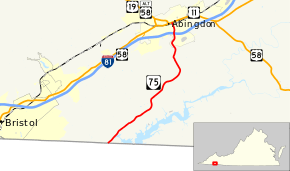
State Route 75 (SR 75) is a primary state highway in the southwest part of the U.S. state of Virginia, running southwest from U.S. Route 11 and U.S. Route 58 Alternate in Abingdon to Tennessee's State Route 44.
Route description
SR 75 crosses the Tennessee state line from State Route 44 in the Holston Valley, formed by the South Fork Holston River. It crosses the low McConnell Ridge at Green Spring into the Watauga Valley, and after running through that valley for a while it turns north to cross the Great Knobs, mostly along a small creek. SR 75 enters the town of Abingdon and crosses Interstate 81/U.S. Route 58, at which point U.S. Route 58 Alternate begins along SR 75, and then ends at the intersection with U.S. Route 11 downtown.
History
The road from Abingdon northwest to Dickensonville (now part of U.S. Route 58 Alternate) was part of the original state highway system designated in 1918,[2] as a spur of State Route 10 (now U.S. Route 11).[3] It was assigned the number State Route 106 in the 1923 renumbering, and it was extended south and southwest five miles (8 km) towards the Tennessee state line in 1925.[4] In the 1928 renumbering, the whole of SR 106 became State Route 110, and extensions added 3.12 miles (5.02 km) in 1929[5] and another 3.24 miles (5.21 km) in 1931.[6]
U.S. Route 19 was added from Abingdon northwest to Hansonville in the late 1920s.[7] Thus, SR 110 was split in the 1933 renumbering; the short piece northwest of Hansonville became part of State Route 71 (which mainly replaced State Route 107). The piece south of Abingdon became State Route 77, and, later that year, the final 0.14 miles (0.23 km) to the Tennessee state line were added.[8] In the 1940 renumbering, SR 77 was renumbered State Route 75, as Virginia expected Tennessee to renumber its State Route 44 to match, but this never happened.[9]
Major intersections
The entire route is in Washington County.
| Location | mi[1] | km | Destinations | Notes | |
|---|---|---|---|---|---|
| | 0.00 | 0.00 | Tennessee state line | ||
| Abingdon | 9.73 | 15.66 | Exit 17 (I-81), eastern terminus of US 58 Alt., southern end of US 58 Alt. concurrency | ||
| 10.51 | 16.91 | Northern end of US 58 Alt. concurrency | |||
1.000 mi = 1.609 km; 1.000 km = 0.621 mi
| |||||
References
- 1 2 "2005 Virginia Department of Transportation Jurisdiction Report - Daily Traffic Volume Estimates - Washington County" (PDF). (356 KiB)
- ↑ State Highway Commission of Virginia (July 5, 1922). Minutes of the First Meeting of the State Highway Commission Created Under the Acts of 1922 (PDF) (Report). Richmond, VA: Commonwealth of Virginia., Proposed "State Highway System" for Virginia, as Recommended by the State Roads Committee, January, 1918
- ↑ State Highway Commission of Virginia (December 15–16, 1922). Minutes of the Seventh Meeting of the State Highway Commission (PDF) (Report). Richmond, VA: Commonwealth of Virginia., page 5
- ↑ State Highway Commission of Virginia (February 25, 1925). Minutes of Meeting (PDF) (Report). Richmond, VA: Commonwealth of Virginia., page 2
- ↑ State Highway Commission of Virginia (August 15, 1929). Minutes of Meeting (PDF) (Report). Richmond, VA: Commonwealth of Virginia., page 15
- ↑ State Highway Commission of Virginia (December 18, 1930). Minutes of Meeting (PDF) (Report). Lynchburg, VA: Commonwealth of Virginia., page 5
- ↑ Virginia Highways Project: US 19
- ↑ State Highway Commission of Virginia (October 19, 1933). Minutes of Meeting (PDF) (Report). Richmond, VA: Commonwealth of Virginia., page 21
- ↑ State Highway Commission of Virginia (October 10, 1940). Minutes of Meeting (PDF) (Report). Richmond, VA: Commonwealth of Virginia., page 12
External links
| < SR 105 | Spurs of SR 10 1923-1928 |
SR 107 > |
| < SR 109 | District 1 State Routes 1928–1933 |
SR 111 > |