Virginia State Route 111
| ||||
|---|---|---|---|---|
 | ||||
| Route information | ||||
| Maintained by VDOT | ||||
| Length: | 2.26 mi[1] (3.64 km) | |||
| Existed: | 1933 – present | |||
| Major junctions | ||||
| West end: |
| |||
| East end: |
| |||
| Location | ||||
| Counties: | Montgomery | |||
| Highway system | ||||
| ||||

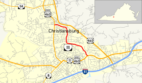
State Route 111 (SR 111) is a primary state highway in the U.S. state of Virginia. The state highway runs 2.26 miles (3.64 km) from U.S. Route 460 Business (US 460 Business) east to US 11 and US 460 Business within Christiansburg.
Route description
SR 111 begins at an intersection with US 460 Business (Franklin Street) on the north side of the town of Christiansburg. The intersection is immediately south of the business route's interchange with mainline US 460. SR 111 heads east as Cambria Street, which parallels the US 460 freeway to just west of Yellow Sulphur Road, where the street curves south. The state highway has a grade crossing of Norfolk Southern Railway's Christiansburg District immediately before curving to the east. Within the curve, SR 111 intersects Depot Street, which heads south to downtown Christiansburg. SR 111 continues east along Depot Street parallel to the rail line, then veers southeast to the highway's eastern terminus at US 11 and US 460 Business (Roanoke Street) on the east side of Christiansburg.[1][2]
Major intersections
The entire route is in Christiansburg, Montgomery County.
| mi[1] | km | Destinations | Notes | ||
|---|---|---|---|---|---|
| 0.00 | 0.00 | Western terminus | |||
| 2.26 | 3.64 | Eastern terminus | |||
| 1.000 mi = 1.609 km; 1.000 km = 0.621 mi | |||||
References
- 1 2 3 "2010 Traffic Data". Virginia Department of Transportation. 2010. Retrieved 2011-10-25.
- ↑ Google (2011-10-25). "Virginia State Route 111" (Map). Google Maps. Google. Retrieved 2011-10-25.
External links
| < SR 217 | District 2 State Routes 1928–1933 |
SR 219 > |