Virginia State Route 26
| ||||
|---|---|---|---|---|
| Oakville Road | ||||
 | ||||
| Route information | ||||
| Maintained by VDOT | ||||
| Length: | 12.83 mi[1] (20.65 km) | |||
| Existed: | 1933 – present | |||
| Major junctions | ||||
| South end: |
| |||
| North end: |
| |||
| Location | ||||
| Counties: | Appomattox | |||
| Highway system | ||||
| ||||

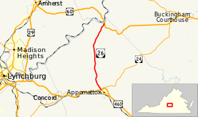
State Route 26 (SR 26) is a primary state highway in the U.S. state of Virginia. Known as Oakville Road, the state highway runs 12.83 miles (20.65 km) from U.S. Route 460, SR 24, and US 460 Business in Appomattox north to US 60 in Bent Creek.
Route description
SR 26 begins as a four-lane divided highway at a diamond interchange with US 460 and SR 24 (Richmond Highway) just north of the town of Appomattox. The roadway continues south of the expressway bypass of the town as US 460 Business (Confederate Boulevard), which leads to the Appomattox Historic District. SR 26 reduces to two lanes and heads north as Oakville Road through northwestern Appomattox County. The state highway passes through the hamlet of Oakville. Near the northern end of SR 26, the highway descends into the narrow valley of Bent Creek. The state highway crosses the stream just south of the stream's mouth at the James River. A short distance to the north, SR 26 reaches its terminus at US 60 (James Anderson Highway) in the hamlet of Bent Creek just south of the U.S. Highway's crossing of the James River.[1][2]
Major intersections
The entire route is in Appomattox County.
| Location | mi[1] | km | Destinations | Notes | |
|---|---|---|---|---|---|
| Appomattox | 0.00 | 0.00 | Interchange | ||
| Bent Creek | 12.83 | 20.65 | |||
| 1.000 mi = 1.609 km; 1.000 km = 0.621 mi | |||||
References
- 1 2 3 "2009 Traffic Data". Virginia Department of Transportation. 2009. Retrieved 2011-08-16.
- Appomattox County (PDF)
- ↑ Google (2011-08-16). "Virginia State Route 26" (Map). Google Maps. Google. Retrieved 2011-08-16.
External links
| < SR 306 | District 3 State Routes 1928–1933 |
SR 308 > |
| < SR 326 | District 3 State Routes 1928–1933 |
none |