Virginia State Route 255
| ||||
|---|---|---|---|---|
 | ||||
| Route information | ||||
| Maintained by VDOT | ||||
| Length: | 3.84 mi[1] (6.18 km) | |||
| Existed: | 1933 – present | |||
| Major junctions | ||||
| South end: |
| |||
| North end: |
| |||
| Location | ||||
| Counties: | Clarke | |||
| Highway system | ||||
| ||||

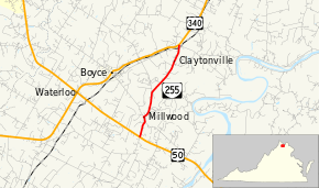
State Route 255 (SR 255) is a primary state highway in the U.S. state of Virginia. Known as Bishop Meade Highway, the state highway runs 3.84 miles (6.18 km) from U.S. Route 17 and US 50 near Millwood north to US 340 at Briggs in southern Clarke County.
SR 255 is a Virginia Byway.
Route description
SR 255 begins at an intersection with US 17 and US 50 (Millwood Pike) south of Millwood. The state highway heads north as a two-lane road through the village of Millwood, the location of several historic sites including the estate Carter Hall. SR 255 continues north through the hamlet of Claytonville. The state highway passes under Norfolk Southern Railway's Hagerstown District before reaching its eastern terminus at US 340 (Lord Fairfax Highway) in the village of Briggs.[1][2]
Major intersections
The entire route is in Clarke County.
| Location | mi[1] | km | Destinations | Notes | |
|---|---|---|---|---|---|
| | 0.00 | 0.00 | |||
| Millwood | south end of SR 723 overlap; former US 50 east | ||||
| north end of SR 723 overlap; former US 50 west | |||||
| Briggs | 3.84 | 6.18 | |||
| 1.000 mi = 1.609 km; 1.000 km = 0.621 mi | |||||
References
- 1 2 3 "2010 Traffic Data". Virginia Department of Transportation. 2010. Retrieved 2011-12-19.
- Clarke County (PDF)
- ↑ Google (2011-12-19). "Virginia State Route 255" (Map). Google Maps. Google. Retrieved 2011-12-19.
External links
| < SR 810 | District 8 State Routes 1928–1933 |
SR 812 > |