Statham's Quarry
Statham's Quarry (also known as Darling Range Quarry, and then Perth City Council's Darling Range Quarry after 1920) is the site of a quarry on the Darling Scarp on the southern side of the entrance of the Helena River valley on to the Swan Coastal Plain in Perth, Western Australia. It is located in Gooseberry Hill and is within the bounds of the Gooseberry Hill National Park
History
Statham's Quarry is considered a rare example of a stone quarry which has retained physical evidence of its operations and is associated with the development of the quarry industry in Western Australia.[1]
The quarry was established by Thomas Statham and William Burton[2] in 1894[3][4] until Statham's death in 1920.
The Perth City Council operated the quarry following Statham's death [5] and material from the quarry was used to as street paving in Perth during the early 1900s.[1] The rocks for the groyne at City Beach also came from the quarry [6]
There was also a clay quarry operation known as Statham's in Glen Forrest which was a brickworks.
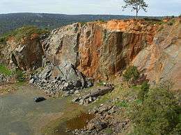
The quarry is the claimed location of one of the most extensive dolerite dikes on the Darling Scarp.[7]
The quarry was serviced by the Kalamunda Zig Zag section of the Upper Darling Range Railway during the time of its operation (which closed in 1949), and was finally put out of operation by a bushfire in 1957. The location has been susceptible to bushfires, the most recent being in the early 2000s which was severe and very hot, reducing the ground cover around the quarry and adjacent country severely.
Current usage
The main current usage of the quarry is rock climbing and abseiling, with the Department of Parks and Wildlife providing facilities and maintaining the site. Dangerous areas are signed and fenced off.
The quarry's importance as a safe easily accessible and well maintained climbing and abseiling location close to the metropolitan area of Perth can be found in the climbing records.[8]
Map
- Allen, M. W.(1928) Darling Range Quarry [cartographic material] : City of Perth. Perth, W.A. Scale 1:792 [1 in. = 1 chain] (Battye Library catalogue description: Map of Perth City Council's Darling Range Quarry (Statham's Quarry) showing the quarry face with contours, railway and sidings, buildings, fences, telephone lines, pipes, formation of Canning Jarrah Timber Company's old line, Ridge Hill and Stathams (old) sidings, watercourses, heights above sea level, boundary of Perth City Council reserve. Battye accession number 009255.
Notes
| Wikimedia Commons has media related to Stathams Quarry. |
- 1 2 "Register of Heritage Places - Interim entry" (PDF). Heritage Council of Western Australia. 11 August 2006. Retrieved 2008-08-24.
- ↑ "Register of Heritage Places - Assessment Doc'n Government Quarries (fmr)" (PDF). Heritage Council of Western Australia. 07/09/2006. Retrieved 2008-08-25. Check date values in:
|date=(help) - ↑ Description of granite quarry owned by Statham (near Zig Zag railway) The West Australian, 4 May 1894, p.3
- ↑ The West Australian 29 August 1898, p.3 Darling Range Quarries - Ministerial visit to the quarry and inspection of new machinery
- ↑ "Opening of the Municipal Quarry at Statham's Siding Last Week by His Excellency the Governor.". Western Mail (Perth, WA : 1885 - 1954). Perth, WA: National Library of Australia. 17 January 1924. p. 23. Retrieved 2 May 2012.
- ↑ Statham's Quarry Walk Trail pamphlet - Kalamunda Shire Council
- ↑ Notes in the Stathams Quarry Walk Trail pamphlet produced by the Shire of Kalamunda
- ↑ http://www.climberswa.asn.au
Further reading
- Mansfield, Frank (2004), Statham's Quarry, F. Mansfield, retrieved 2 May 2012(typescript at Battye Library)
Coordinates: 31°56′3″S 116°2′53″E / 31.93417°S 116.04806°E