Statistical regions of Latvia
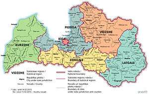
There are six statistical regions in Latvia[1] (Latvian: Latvijas statistiskie reģioni) are Kurzeme, Latgale, Pieriga, Riga, Vidzeme and Zemgale.
Statistical regions were established according to the main principles set out in the Regulation (EC) No 1059/2003 of the European Parliament and of the Council of 26 May 2003 on the establishment of a common classification of territorial units for statistics (NUTS)[2] (hereinafter NUTS Regulation), further amended. This NUTS Regulation directly concerns all Member States of the European Union and from 1 May 2004 it is also binding upon Latvia.
The statistical regions of Latvia are not administrative regions, as they have been formed for statistical purposes. Therefore, they are not mentioned in the law that determines the administrative divisions of Latvia.[3]
The structure of Statistical Regions is approved by order No. 271 of the Cabinet of Ministers dated 28 April 2004 "On the Statistical Regions of the Republic of Latvia and Administrative Units Therein", further amended.[4]
The Structure of Statistical regions of Latvia
Statistics
| NUTS Code | Regions | Largest City | Area | Population* – (per km²) |
|---|---|---|---|---|
| LV006 | Rīga | Rīga | 304 km² | 643,368 - (2,118/km²) |
| LV007 | Pierīga | Jūrmala | 10,134 km² | 367,038 – (36/km²) |
| LV003 | Kurzeme | Liepāja | 13,606 km² | 258,034 – (19/km²) |
| LV005 | Latgale | Daugavpils | 14,550 km² | 286,238 – (20/km²) |
| LV009 | Zemgale | Jelgava | 10,732 km² | 244,875 – (23/km²) |
| LV008 | Vidzeme | Valmiera | 15,245 km² | 201,915 – (13/km²) |
| LV00 | Latvija | Rīga | 64,572 km² | 2,001,468 – (31/km²) |
| * Data as of 1 January 2014 |
History
NUTS Regulation was established to divide economic territory of EU[5] into similar territorial units for the purpose of collection, compilation and dissemination of harmonised regional statistics in the EU. Shortly before accession to EU, Central Statistical Bureau of Latvia, the The Ministry of Environmental Protection and Regional Development and representatives of the planning regions came to an agreement about the structure of statistical regions (order No.271 of the Cabinet of Ministers dated 28 April 2004 “On the Statistical Regions of the Republic of Latvia and Administrative Units Therein”, further amended.)
Statistical regions of Latvia were approved by Regulation (EC) No 1888/2005 of the European Parliament and of the Council of 26 October 2005 amending Regulation (EC) No 1059/2003 on the establishment of a common classification of territorial units for statistics (NUTS) by reason of the accession of the Czech Republic, Estonia, Cyprus, Latvia, Lithuania, Hungary, Malta, Poland, Slovenia and Slovakia to the European Union.
The four statistical regions Kurzeme, Latgale, Vidzeme and Zemgale align with the planning regions of Latvia[6] (Regulation No.391 of the Cabinet of Ministers dated 5 May 2009 “On the territories of the Planning Regions.”, further amended),[7] but Rīga and Pierīga statistical regions comprise the territory of the Rīga planning region.
References
- ↑ "Par Latvijas statistiskajiem reģioniem" (in Latvian). Central Statistical Bureau.
- ↑ "Nomenclature of territorial units for statistics (NUTS)". Eurostat.
- ↑ "Administratīvo teritoriju un apdzīvoto vietu likums" (in Latvian). likumi.lv. 2008-12-18. Retrieved 2011-12-15.
- ↑ "Par Latvijas Republikas statistiskajiem reģioniem un tajos ietilpstošajām administratīvajām vienībām" (in Latvian). likumi.lv. 2004-04-28. Retrieved 2010-12-28.
- ↑ "Eurostat: Glossary". Eurostat.
- ↑ "Plānošanas reģioni" (in Latvian). Ministry of Environmental Protection and Regional Development. Retrieved 2012-02-28.
- ↑ "Noteikumi par plānošanas reģionu teritorijām" (in Latvian). likumi.lv. 2009-05-05. Retrieved 2011-04-02.