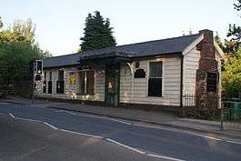
Stockton Brook railway station
| Stockton Brook | |
|---|---|
|
The disused station buildings, on the bridge above the railway | |
| Location | |
| Place | Stoke-on-Trent |
| Area | Staffordshire |
| Operations | |
| Original company | North Staffordshire Railway |
| Platforms | 1 |
| History | |
| 1 July 1896 | Opened[1] |
| 7 May 1956 | Closed[1] |
| Disused railway stations in the United Kingdom | |
|
Closed railway stations in Britain A B C D–F G H–J K–L M–O P–R S T–V W–Z | |
|
| |
Stockton Brook railway station is a disused railway station in Staffordshire.
The Stoke–Leek line was opened by the North Staffordshire Railway (NSR) in 1867[2] but it wasn't 1896 that a station to serve the village of Stockton Brook was built. Situated on the single track section of the line between Milton Junction (where the line diverged from the Biddulph Valley line) and Endon, the station had only a single platform situated in a shallow cutting. The station buildings were at street level. During the LMS period the station was known as Stockton Brook for Brown Edge.[3]
Passenger services over the line were withdrawn in 1956 and the station closed. The station buildings remain in existence and are now a shop. The line through the station continued in use until 1988 for freight services and since then the line has officially been out of use but not closed.
| Preceding station | Disused railways | Following station | ||
|---|---|---|---|---|
| Milton Line open, station closed |
North Staffordshire Railway Stoke–Leek line |
Endon Line open, station closed | ||
References
- Notes
- 1 2 Quick (2009), p. 367.
- ↑ Christiansen & Miller (1971), p. 300.
- ↑ Jeuda (2014), p. 142.
- Sources
- Christiansen, Rex & Miller, Robert William (1971). The North Staffordshire Railway. Newton Abbot, Devon: David & Charles. ISBN 0-7153-5121- 4.
- Jeuda, Basil (2014). The North Staffordshire Railway in LMS days. 3. Lydney, Gloucestershire: Lightmoor Press. ISBN 978-1899889-83-9.
- Quick, Michael (2009) [2001]. Railway passenger stations in Great Britain: a chronology (4th ed.). Oxford: Railway and Canal Historical Society. ISBN 978-0-901461-57-5. OCLC 612226077.
Coordinates: 53°03′57″N 2°07′24″W / 53.0657°N 2.1234°W
