Storslett
| Storslett | |
|---|---|
| Village | |
|
View of the village | |
 Storslett  Storslett Location in Troms | |
| Coordinates: 69°46′05″N 21°01′28″E / 69.76806°N 21.02444°ECoordinates: 69°46′05″N 21°01′28″E / 69.76806°N 21.02444°E | |
| Country | Norway |
| Region | Northern Norway |
| County | Troms |
| District | Nord-Troms |
| Municipality | Nordreisa |
| Area[1] | |
| • Total | 1.62 km2 (0.63 sq mi) |
| Elevation[2] | 2 m (7 ft) |
| Population (2013)[1] | |
| • Total | 1,781 |
| • Density | 1,099/km2 (2,850/sq mi) |
| Time zone | CET (UTC+01:00) |
| • Summer (DST) | CEST (UTC+02:00) |
| Post Code | 9151 Storslett |
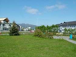
Storslett is a village and the administrative centre of the municipality of Nordreisa in Troms county, Norway. The village is located at the southern end of the Reisafjorden along the mouth of the river Reisaelva. The 1.62-square-kilometre (400-acre) village has a population (2013) of 1,781 which gives the village a population density of 1,099 inhabitants per square kilometre (2,850/sq mi).[1]
Nordreisa Church and Nordreisa's upper secondary school are located in Storslett. The small Sørkjosen Airport is located in the neighboring village of Sørkjosen, about 5 km (3.1 mi) to the northwest. European route E6 passes through this village.
Storslett was completely destroyed during World War II in 1944 at the end of the occupation of Norway by Nazi Germany; however, the village area was completely rebuilt and has had strong growth since the war.[3]
References
- 1 2 3 Statistisk sentralbyrå (1 January 2013). "Urban settlements. Population and area, by municipality.".
- ↑ "Storslett" (in Norwegian). yr.no. Retrieved 2012-12-22.
- ↑ Store norske leksikon. "Storslett" (in Norwegian). Retrieved 2010-03-31.