Strait of Gibraltar crossing
The Strait of Gibraltar crossing is a hypothetical bridge or tunnel spanning the Straits of Gibraltar that would connect Europe and Africa. The governments of Spain and Morocco appointed a joint committee[1] to investigate the feasibility of linking the two continents, which resulted in the much broader Euromed Transport project.[2]
Bridge
Several engineers have designed bridges on various alignments and with differing structural configurations. Professor T.Y. Lin’s proposal for a crossing between Point Oliveros and Point Cirse featured deep piers, a length of 14 kilometres (9 miles), 910-metre-tall (3,000 ft) towers, and a 5,000-metre (16,000-foot) span, more than twice the length of the current longest bridge span.[3]
In 2004, architect Eugene Tsui published his concept for a floating and submerged bridge, connected at a three-mile wide island in the middle of the Mediterranean Sea.[4]
In 2004, the Science Museum, London published an image of the proposed Gibraltar Straits road bridge.[5]

Tunnel
Various tunnels have been proposed. Spain first proposed a modern tunnel under the Strait of Gibraltar in 1930. A major problem arose when the engineers hired by the Spanish government discovered that the material under the Strait was extremely hard rock, making tunnelling impossible with the available technology.[6] One engineering solution was to fix, using cables, a prefabricated concrete tunnel to the floor of the Strait. This tunnel would handle automotive and train traffic. Nothing came of this proposed solution.[7]
A 2008 geological study cast doubt on the tunnel's practicality. In March 2009, a contract was issued for a joint system linking the Moroccan Société Nationale d'Etudes du Détroit de Gibraltar (SNED) with its Spanish counterpart, Sociedad española de estudios para la comunicación fija a través del Estrecho de Gibraltar S.A (SECEGSA). A three-year study for a railway tunnel was announced in 2003. SNED and SECEGSA commissioned several seabed surveys.
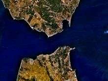
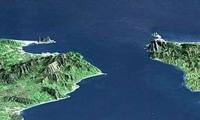
The Strait depth extends to 900 metres (3,000 ft) on the shortest route, although it is only about 300 metres deep slightly further west, where the European and African tectonic plates meet. The shortest crossing is 14 kilometres (8.7 mi). The proposed route of 23 kilometres (14 mi) is west of Tarifa and to the east of Tangier. The tunnel is likely to be about 34 kilometres (21 miles) in all. It is proposed that a connection would have to be made to the Spanish high speed railway network, which has a line projected to be built from Cádiz to Málaga via Algeciras.
A report[8][9][10] on the feasibility of the tunnel was presented to the EU in 2009. A further project study is under development by a group of specialist consultants from SYSTRA, Amberg and COWI.
Planning
In December 2003, Spain and Morocco agreed[11][12] to explore the construction of an underwater rail tunnel to connect their rail systems. The tunnel would have linked Cape Malabata near Tangier with Punta Paloma in the El Estrecho Natural Park 40 kilometres (25 mi) west of Gibraltar.[13] In late 2006, Lombardi Engineering Ltd, a Swiss engineering and design company, was retained to draft a design for a railway tunnel.[14] According to the company, the main differences between the construction of this tunnel and that of the Channel Tunnel, linking France and Great Britain, are the depth of the sea and the geological conditions. The area under the Strait is less stable than that under the English Channel. An active major geologic fault, the Azores–Gibraltar Transform Fault, bisects the Strait, and severe earthquakes have occurred in the area. The presence of two deep Quaternary clay channels in the middle of the Strait makes construction complex,[8] causing doubts about the feasibility of the project and proposals for an exploratory tunnel.[15]
No official figures about the cost of the project had been announced by 2007, but previous estimates exceeded €5 billion.[16]
Technical aspect
The proposed rail tunnel's length is 40 kilometres (25 mi), 300 metres (980 ft) deep,[9] and its construction would take 15 years. An earlier plan was to link the two continents via the narrowest part of the strait, but this idea was dismissed as it is 900 metres (3,000 ft) below sea level and the deepest undersea tunnel, the Eiksund Tunnel, is 287 metres (942 ft) below sea level.
The construction of terminals, such as the Eurotunnel Folkestone Terminal and Eurotunnel Calais Terminal at either end of the Channel Tunnel, might be required for trans-shipment of road vehicles.
See also
References
- ↑
- ↑ Euromed Transport project 2003 – 2009
- ↑ "Gibraltar Bridge – Feasibility Study". OPAC Consulting Engineers. 2003. Retrieved 2009-03-05.
- ↑ "Strait of Gibraltar Floating Bridge". Tsui Design & Research, Inc. 2004. Retrieved 2009-03-05.
- ↑ Suspension bridge technology
- ↑ "Tunnel from Spain to Africa" Popular Mechanics, March 1930 article bottom-left of page 366
- ↑ "Strangest Tunnel to Join Europe and Africa" Popular Mechanics, August 1930
- 1 2 "Project of the fixed link through the strait of Gibraltar" (PDF). SECEG SA. November 2007. Archived from the original (PDF) on 19 February 2009. Retrieved 3 February 2009.
- 1 2 Wood, Danny (19 July 2008). "Spain-Africa link decision 'near'". BBC News. Retrieved 2008-07-20.
- ↑ "El proyecto del túnel del Estrecho llegará en 2009 a manos de la UE en busca de apoyos". 20 minuto.es (in Spanish). 16 November 2008. Retrieved 3 February 2009.
- ↑ "Europe-Africa rail tunnel agreed". BBC News. 14 December 2003. Retrieved 3 February 2009.
- ↑ "Africa and Europe set for tunnel link". BBC News. 13 March 2007. Retrieved 3 February 2009.
- ↑ "Spain and Morocco agree to rail tunnel under Gibraltar strait". wsws.org. Retrieved 2007-01-10.
- ↑ swissinfo with agencies. "Swiss plan tunnel under Strait of Gibraltar". swissinfo.org. Retrieved 2007-01-10.
- ↑ "Doubts cast over tunnel plan". Middle East Online. Sep 29, 2008. Retrieved Feb 3, 2015.
- ↑ Tremlett, Giles (20 October 2006). "By train from Europe to Africa – undersea tunnel project takes a leap forward". The Guardian. London. Retrieved 2007-01-10.
External links
- "Gibraltar: Tunnel under troubled waters". 30 June 2008. Retrieved 3 February 2009.
- A man from Ticino to link Europe and Africa
- "Website of the project of the fixed link through the Strait of Gibraltar". Archived from the original on 16 May 2007. Retrieved 3 February 2009.
- SNED
- SECEGSA
Coordinates: 35°57′55″N 5°34′24″W / 35.96528°N 5.57333°W