Strowan
| Strowan | |
|---|---|
|
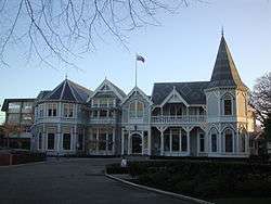
Strowan House, the administration building of St. Andrew's College | |
| Coordinates: 43°30′30″S 172°36′35″E / 43.50833°S 172.60972°ECoordinates: 43°30′30″S 172°36′35″E / 43.50833°S 172.60972°E | |
| Area | |
| • Total | 1.5977 km2 (0.6169 sq mi) |
| Population (2006) | |
| • Total | 3,957 |
| • Density | 2,500/km2 (6,400/sq mi) |
Strowan is a suburb of Christchurch, New Zealand. It is located between the suburbs of Merivale (south), Papanui (north), Bryndwr (north-west), Fendalton (south-west), and St Albans (east). The area is predominantly residential, containing mostly parks and schools and few retail or commercial buildings. A prestigious private school in the area is St. Andrew's College.
| Wikimedia Commons has media related to Strowan. |
This article is issued from Wikipedia - version of the 7/11/2016. The text is available under the Creative Commons Attribution/Share Alike but additional terms may apply for the media files.