Sunzha River
| Sunzha River | |
|---|---|
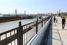 Sunzha River in Grozny | |
| Country | North Ossetia, Ingushetia and Chechnya, Russia |
| Basin | |
| Main source | Caucasus Major, North Ossetia |
| River mouth | Terek |
| Basin size | 12,200 km2 (4,700 sq mi) |
| Physical characteristics | |
| Length | 278 km (173 mi) |
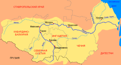
The Sunzha (Russian: Су́нжа; IPA: [ˈsunʐə], Ossetian: Сунжæ, Sunžæ; IPA: [sunʒə], Chechen: Соьлжа, Sölƶa[1]) is a river in North Ossetia, Ingushetia and Chechnya, Russia, a tributary of the Terek River. It flows northeast inside the great northwest bend of the Terek River and catches most of the rivers that flow north from the mountains before they reach the Terek. It is 278 kilometres (173 mi) long. The Sunzha rises on the Northern slope of the Caucasus Major. Its major tributaries are the Assa River and Argun River. With a turbidity of 3,800 grams per cubic metre (6.4 lb/cu yd), it carries 12.2 million tons of alluvium per year. It is used for irrigation. Cities that lie on the Sunzha include Nazran, Karabulak, Grozny (the capital of Chechnya), and Gudermes. During the First and Second Chechen Wars, the destruction of petroleum reservoirs caused the Sunzha to become polluted with petroleum.[2]
Nomenclature
The origin of the name of the river has some versions. The most probable of versions name Sunzha has come from Mongol-Turkic languages in the deformed type. It is known, that Mongols called it Suinchie, Russian Sevenz and in the Chechen language it is names has got in corrective type Solchzha.
There is also other version that the river Sunzha Chechens called before Okhi «Oh'-hi, Оhhи » that means in translation with Chechen – «downwards the river».
See also
- Valerik River- historically notable tributary of Sunzha
References
- ↑ Lepiev A.S., Lepiev İ.A., Türkçe-Çeçençe sözlük, Turkoyŋ-noxçiyŋ doşam, Ankara, 2003
- ↑ John Daniszewski (March 11, 2001). "Chechens Find a Way to Live Off the Land--Through Oil". Los Angeles Times. Retrieved September 28, 2007.
Coordinates: 43°26′27″N 46°08′05″E / 43.44083°N 46.13472°E