Swallow Falls State Park
| Swallow Falls State Park | |
| Maryland State Park | |
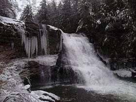 Muddy Creek Falls | |
| Country | United States |
|---|---|
| State | Maryland |
| County | Garrett |
| Elevation | 2,382 ft (726.0 m) [1] |
| Coordinates | 39°29′48″N 79°25′31″W / 39.49667°N 79.42528°WCoordinates: 39°29′48″N 79°25′31″W / 39.49667°N 79.42528°W [1] |
| Area | 257 acres (104 ha) [2] |
| Developed | 1930s |
| Management | Maryland Department of Natural Resources |
| IUCN category | V - Protected Landscape/Seascape |
| Nearest city | Oakland, Maryland |
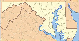 Location in Maryland | |
| Website: Swallow Falls State Park | |
Swallow Falls State Park is a state-owned, public recreation area located on the west bank of the Youghiogheny River 9 miles (14 km) north of Oakland in Garrett County, Maryland, in the United States. The state park features Maryland's highest free-falling waterfall, the 53-foot (16 m) Muddy Creek Falls,[3] as well as smaller waterfalls on the Youghiogheny River and Tolivar Creek.[4] The park is notable for its stand of old hemlock trees,[5] some more than 300 years old, "the last stand of its kind in Maryland."[6]
History
The park had its beginnings in 1906 with the donation by John and Robert Garrett of Baltimore of 1,917 acres (776 ha) to be used as a state forest. The land now known as Garrett State Forest included the areas that became Swallow Falls and Herrington Manor state parks, both of which were developed in the 1930s by the Civilian Conservation Corps.[7][8] Notable persons who have visited the area include Thomas Edison, Henry Ford, John Burroughs, and Harvey Firestone, who camped at Muddy Creek Falls in the summers of 1918 and 1921.[9][10]
Activities and amenities
The park contains 65 campsites, a picnic area with a pavilion and playground, as well as a mile-long hiking trail through the old growth forest. A 5.5-mile (8.9 km) trail for hiking and mountain biking connects the state park with Herrington Manor State Park.[4]
References
- 1 2 "Swallow Falls State Park". Geographic Names Information System. United States Geological Survey.
- ↑ "Fiscal Year 2016 DNR Owned Lands Acreage" (PDF). Maryland Department of Natural Resources. July 29, 2016. Retrieved October 20, 2016.
- ↑ "Muddy Creek Falls, Garrett County". Maryland Geological Survey. Retrieved November 27, 2013.
- 1 2 "Swallow Falls State Park". Maryland Department of Natural Resources. Retrieved November 10, 2014.
- ↑ "The State of Chesapeake Forests" (PDF). The Conservation Fund. 2006. Retrieved November 27, 2013.
Just west of the Chesapeake Bay watershed, in Maryland’s Swallow Falls State Park, an ancient hemlock forest, moist and sensitive to fire, provides a chance to experience a cool, dark woodland, with deadfalls of centuries-old trees.
- ↑ "Youghiogheny Grove". Historical Marker Database. Retrieved July 24, 2015.
- ↑ "Part II: A Maryland Perspective". The Civilian Conservation Corps: Roosevelt's Tree Army in Maryland. Maryland Forest Service. September 19, 2006. Archived from the original on March 6, 2012. Retrieved July 24, 2015.
- ↑ Paula Stoner, Architectural Historian (October 1978). "Inventory Form for State Historic Sites Survey: Swallow Falls–Harrington Manor State Parks" (PDF). Maryland Historical Trust. Retrieved July 24, 2015.
- ↑ "Campsite". Historical Marker Database. Retrieved July 24, 2015.
- ↑ Zumbrun, Francis Champ. "The Vagabonds Camp at Muddy Creek Falls". Famous Travelers: Edison, Ford, Firestone. Maryland Department of Natural Resources. Retrieved November 27, 2013. Originally published in the Cumberland Times-News, November 1, 2008.
External links
| Wikimedia Commons has media related to Swallow Falls State Park. |
- Swallow Falls State Park Maryland Department of Natural Resources
- Swallow Falls State Park Protected Planet