Tagalaht
| Tagalaht | |
| Tagga Bay, Taggaviken | |
| Bay | |
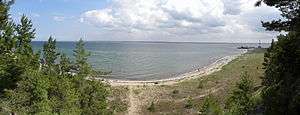 Tagalaht Bay Panorama | |
| Country | Estonia |
|---|---|
| County | Saare County |
| Part of | Baltic Sea |
| Mouth | |
| - coordinates | EE 58°31′N 22°4′E / 58.517°N 22.067°ECoordinates: EE 58°31′N 22°4′E / 58.517°N 22.067°E |
 Tagga Bay marked on a satellite image of Saaremaa. | |
Tagalaht (Swedish: Taggaviken) is a bay in the Baltic Sea, on the north-west coast of Saaremaa Island in Estonia, situated between the Tagamõisa Peninsula (German: Hundsort) and Ninase (Cape Ninnast). During World War I, the bay, guarded by Russian beach forts at Hundsort and Ninnast, was the main landing point for German troops during Operation Albion in October 1917, when Saaremaa was occupied.[1]
References
- ↑ Barrett, Michael B. Operation Albion: The German Conquest of the Baltic Islands. Indiana University Press: Bloomington, IN. ISBN 978-0-253-34969-9
This article is issued from Wikipedia - version of the 8/3/2015. The text is available under the Creative Commons Attribution/Share Alike but additional terms may apply for the media files.