Tagong
| Tagong Lhagang | |
|---|---|
| Township | |
| Tibetan transcription(s) | |
| • Tibetan | ལྷ་སྒང་ |
| • Wylie transliteration | lha sgang |
| Chinese transcription(s) | |
 Tagong Location of the county | |
| Coordinates: 30°19′18″N 101°31′11″E / 30.32167°N 101.51972°ECoordinates: 30°19′18″N 101°31′11″E / 30.32167°N 101.51972°E | |
| Country | China |
| Province | Sichuan |
| Prefecture | Garzê Tibetan Autonomous Prefecture |
| County | Kangding County |
| Time zone | CST (UTC+8) |
Tagong (塔公), also known as Lhagang (ལྷ་སྒང་) is a small town in Garzê Tibetan Autonomous Prefecture of western Sichuan Province, in southwestern China. It is located in the historical Kham region of eastern Tibet.
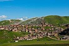
Tagong.
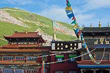
Tagong Monastery.
Tagong Monastery
It is the location of Tagong Monastery — a Tibetan Buddhist monastery and one of the most important in the area — in Tibetan Pel Lhagong.
It was established with reference to a nearby sacred mountain, Mt. Yala or Zhara Lhaste, 5,820 metres (19,090 ft) in elevation.
Tagong Grassland
Tagong Grassland has an area of 712.37 square kilometres and located at 3900m in elevation.
See also
![]() Media related to Tagong Monastery at Wikimedia Commons
Media related to Tagong Monastery at Wikimedia Commons
This article is issued from Wikipedia - version of the 6/26/2016. The text is available under the Creative Commons Attribution/Share Alike but additional terms may apply for the media files.