Talanga
| Talanga | |
|---|---|
| Municipality | |
|
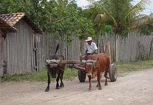
Road in Talanga | |
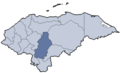
 Talanga Location in Honduras | |
| Coordinates: 14°24′N 87°5′W / 14.400°N 87.083°W | |
| Country | Honduras |
| Department | Francisco Morazán |
| Area | |
| • Total | 418 km2 (161 sq mi) |
| Population (2015) | |
| • Total | 35,843 |
| • Density | 86/km2 (220/sq mi) |
Talanga is a municipality in the Honduran department of Francisco Morazán.
It lies on the highway connecting Tegucigalpa with the department of Olancho. Talanga is a medium-sized municipality relying heavily on agriculture. Its most important crops include corn, sugar cane and livestock fodder.
Perhaps the most notable feature of Talanga is that the streets are all dirt. In most towns of its size in Honduras, the primary streets are paved. The town is just finishing installing a sewer system (as of 2006) and paving is an upcoming project. For now, the town is the epitome of "wild, wild west," with ox carts, cowboys on horseback, stray dogs, untended livestock, and minimal law enforcement. Talanga has a very good indoor market with produce, meat, pots and pans, and other household goods. There are about seven well-stocked hardware stores, as well as two internet cafes. The town square was recently built with concrete fixtures and a basketball court. There is a hill with a cross near the town center with an excellent view of the town and surrounding area. The people of Talanga are very friendly and one would be hardpressed to walk the main street without having people say "buenas" and starting conversations.
Coordinates: 14°24′0″N 87°5′0″W / 14.40000°N 87.08333°W