Alakkode Road
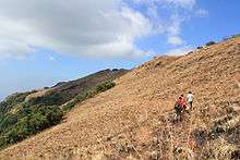
Paithalmala hills
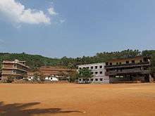
Chapparappadavu Highschool
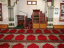
Syed Nagar Mosque
Alakkode Road is a suburb of Taliparamba town consisting a number of small and populated villaged on the road to Alakode.
| Taliparamba East | |
|---|---|
| Coordinates: 12°04′09″N 75°23′08″E / 12.0690347°N 75.3856087°ECoordinates: 12°04′09″N 75°23′08″E / 12.0690347°N 75.3856087°E |
Populated Villages
- Kooveri. 18,000 people
- Kuttiyeri. 10,528 people
- Panniyoor. 10,722 people
- Chapparapadavu 14,883 people
- Kanhirangad 5,000 people
- Alakode 33, 600 people
- Kooveri 17,908 people
- Eruvassy. 19,175 people
Paithalmala Hills
Paithalmala is a hill station near Taliparamba on the way to Alakode. It is 1371 meters above sea level and attracts many trekkers. It is nestled in the Kodagu forests on the border with the neighboring Karnataka province.
Chapparapadavu
Chapparapadavu is a village (panchayath) in Kannur district in the Indian state of Kerala.[1] The villages of Koovery, Kottakkanam, and Therandi are part of the panchayath. Chapparapadavu has 14,883 people.
Image gallery
-
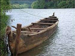
Boat at Cheriyoor
-

Cheriyoor village
Location
 |
Payyannur | Vellora | Alakkode, Chapparappadavu | |
| Pazhayangadi | |
Sreekandapuram, Irikkkur | ||
| ||||
| | ||||
| Cherukunnu, Kannapuram | Kannur | Mayyil |
See also
References
- ↑ "Census of India : Villages with population 5000 & above". Archived from the original on December 8, 2008. Retrieved 2008-12-10.
|first1=missing|last1=in Authors list (help)
| Wikimedia Commons has media related to Taliparamba. |
This article is issued from Wikipedia - version of the 12/1/2016. The text is available under the Creative Commons Attribution/Share Alike but additional terms may apply for the media files.