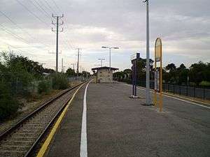
Taperoo railway station
Taperoo | |||||||||||
|---|---|---|---|---|---|---|---|---|---|---|---|
 | |||||||||||
| Location |
Railway Terrace Taperoo | ||||||||||
| Line(s) | Outer Harbor Line | ||||||||||
| Distance | 18.2 km from Adelaide | ||||||||||
| Platforms | 2 | ||||||||||
| Bus routes | None | ||||||||||
| Construction | |||||||||||
| Parking | No | ||||||||||
| Bicycle facilities | No | ||||||||||
| History | |||||||||||
| Opened | 1920 | ||||||||||
| Rebuilt | 1955 | ||||||||||
| Services | |||||||||||
| |||||||||||
Taperoo railway station is located on the Outer Harbor line.[1] Situated in the north-western Adelaide suburb of Taperoo, it is 18.2 kilometres from Adelaide station.
It was originally named Silicate Siding, being renamed Taperoo on 22 November 1920. Originally a step down platform, it was replaced with the current island platform in 1955.
Services by platform
| Platform | Lines | Destinations | Notes |
|---|---|---|---|
| 1 | Outer Harbor | all stops services to Outer Harbor | some peak hour services terminate at Osborne |
| 2 | Outer Harbor | all stops services to Adelaide |
References
- ↑ Outer Harbor & Grange timetable Adelaide Metro 23 February 2014
- Rails Through Swamp and Sand – A History of the Port Adelaide Railway. M. Thompson pub. Port Dock Station Railway Museum (1988) ISBN 0-9595073-6-1
External links
![]() Media related to Taperoo railway station at Wikimedia Commons
Media related to Taperoo railway station at Wikimedia Commons
Coordinates: 34°48′20″S 138°29′57″E / 34.80556°S 138.49905°E
This article is issued from Wikipedia - version of the 10/9/2016. The text is available under the Creative Commons Attribution/Share Alike but additional terms may apply for the media files.