Tarbert, Argyll and Bute
| Tarbert | |
| Scottish Gaelic: Tairbeart Loch Fìne/An Tairbeart | |
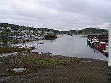
 A view over Tarbert Harbour |
|
 Tarbert |
|
| Population | 1,338 (2001 Census) |
|---|---|
| OS grid reference | NR865685 |
| Council area | Argyll and Bute |
| Lieutenancy area | Argyll and Bute |
| Country | Scotland |
| Sovereign state | United Kingdom |
| Post town | TARBERT |
| Postcode district | PA29 |
| Dialling code | 01880 |
| Police | Scottish |
| Fire | Scottish |
| Ambulance | Scottish |
| EU Parliament | Scotland |
| UK Parliament | Argyll and Bute |
| Scottish Parliament | Argyll and Bute |
Coordinates: 55°51′46″N 5°24′41″W / 55.862805°N 5.41143°W
Tarbert (Scottish Gaelic: An Tairbeart, pronounced [ənˠ̪ t̪aɾʲab̊ərˠʃd̪̊] or Tairbeart Loch Fìne to distinguish it from other places of the same name) is a village in Scotland in the Argyll and Bute council area. It is built around East Loch Tarbert, an inlet of Loch Fyne, and extends over the isthmus which links the peninsula of Kintyre to Knapdale and West Loch Tarbert. Tarbert had a recorded population of 1,338 in the 2001 Census.
Tarbert has a long history both as a harbour and as a strategic point guarding access to Kintyre and the Inner Hebrides. The name Tarbert is the anglicised form of the Gaelic word tairbeart. It is composed of tar "across" and a form of the verb beir "carry" and literally translates as "across-carrying". This refers to the narrowest strip of land between two bodies of water over which goods or entire boats can be carried (portage). In past times cargoes were discharged from vessels berthed in one loch, hauled over the isthmus to the other loch, loaded onto vessels berthed there and shipped onward, allowing seafarers to avoid the sail around the Mull of Kintyre.
Tarbert was anciently part of the Gaelic overkingdom of Dál Riata and protected by three castles — in the village centre, at the head of the West Loch, and on the south side of the East Loch. The ruin of the last of these castles—Tarbert Castle—still exists, and dominates Tarbert's skyline. Around the year 1098 Magnus Barefoot, King of Norway, had his longship carried across the isthmus at Tarbert to signify his possession of the Western Isles.
Despite its distinction as a strategic stronghold during the Middle Ages, Tarbert's socioeconomic prosperity came during the Early Modern period, as the port developed into a fishing town. At its height, the Loch Fyne herring fishery attracted hundreds of vessels to Tarbert.
History

Tarbert is a name from Gaelic for a small neck of land joining two larger pieces; an isthmus, at which Tarbert lies.
Tarbert was anciently part of the Gaelic overkingdom of Dál Riata. It has been suggested as a scene of an action during a conflict for the kingdom's rule between Dúngal mac Selbaig and Eochaid mac Echdach. The Annals of Ulster attest that in 731, Dúngal burnt a "Tairpert Boitir", which was most probably Tarbert and was at the time in the lands of the Cenél nGabráin.[1]
Around the year 1098 Magnus Barefoot, King of Norway, had his longship carried across the isthmus at Tarbert to signify his possession of the Western Isles.
A fortified structure was built in Tarbert during the 13th century. It was reinforced with the addition of an outer bailey and towers in the 1320s by Robert the Bruce, to protect it against the Lords of the Isles. A towerhouse was added in the 16th century, which is the most noticeable part of the remains. The castle occupies high land above Loch Fyne, providing views up East Loch Tarbert and beyond to the Firth of Clyde. This castle was captured from John MacDonald by James IV of Scotland as part of his campaign to destroy the power of the Lords of the Isles. In 1685 the castle was involved in another skirmish when Walter Campbell of Skipness Castle seized it as a stronghold for the Clan Campbell.
There are only a couple of standing walls left and they are considered unstable. The castle is on top of a hill in Tarbert overlooking the bay. The castle has a very commanding view of the water approaches.
Geography
The coast of Tarbert Bay is rocky and the cliffs are fringed with young firs, the village itself being an extremely tranquil and beautiful place. The parish church occupies a fine situation. Overlooking the harbour are the ruins of a castle built by Robert I of Scotland in 1326. The isthmus connecting the districts of Knapdale and Kintyre is little more than one mile wide, and boats once used to be dragged across to the head of West Loch Tarbert, a narrow sea loch nearly ten miles long. A proposal to cut a canal across to shorten the sail to Islay and Jura has never progressed further. Tarbert is famous for its seafood and hosts a seafood festival every year.
In addition to the Seafood Festival, Tarbert also plays host to the Scottish Series, which usually takes place in the last weeks of May every year. This yacht race is the second biggest in Britain and is surpassed only by the Cowes Week. At its peak, the village is swelled by visiting yachtsmen and their yachts.
The A83 road runs 37.8 miles (60.8 km) southwest from Tarbert to Campbeltown.
Governance
Tarbert is represented by several tiers of elected government. Tarbert has a representative, which it shares with North & West Kintyre, on the Argyll and Bute Council, and a community council and community trust shared with the hamlet of Skipness. Tarbert and Skipness Community Council forms the lowest tier of government whose statutory role is to communicate local opinion to local and central government. It is one of 60 community councils of the Argyll and Bute council area. Argyll and Bute Council, the unitary local authority for Tarbert, is based at Lochgilphead, and is the executive, deliberative and legislative body responsible for local government. The Scottish Parliament is responsible for devolved matters such as education, health and justice,[2] while reserved matters are dealt with by the Parliament of the United Kingdom.
Tarbert anciently formed part of the Dál Riata. It has lain within the county boundaries of Argyllshire from a very early time. In 1890, Tarbert fell under the authority of Argyll County Council, where it remained until 1975 when the county was superseded by the regional council area of Strathclyde. From 1975 to 1996, Tarbert was in the Argyll district of Strathclyde until the two-tier regions and districts of Scotland were abolished. Since 1996 it has formed part of the unitary Argyll and Bute council area; Argyll and Bute Council is the local authority. Tarbert remains part of Argyllshire for purposes of registration.
Demography
According to the United Kingdom Census 2001, the census locality (village and sub-area) of Tarbert had a total resident population of 1,338.[3] Over 10% of this population was born in England.
Notable people
People from Tarbert are known locally as "the Dookers".
Sir Donald MacAlister, 1st Baronet of Tarbert KCB (17 May 1854–15 January 1934) was a physician, and principal and vice-chancellor and, later, chancellor of the University of Glasgow.
George Campbell Hay (1915–1984) was a poet and translator, who wrote in Scottish Gaelic, Lowland Scots and English. He was born in Elderslie, Renfrewshire but raised in Tarbert.
References
 This article incorporates text from a publication now in the public domain: Chisholm, Hugh, ed. (1911). "article name needed". Encyclopædia Britannica (11th ed.). Cambridge University Press.
- ↑ John Bannerman, Studies in the History of Dalriada (1974).
- ↑ "Reserved and devolved matters". Scotland Office. Archived from the original on 4 October 2006. Retrieved 2006-11-14.
- ↑ "Comparative Population Profile: Tarbert Locality, Scotland". scrol.gov.uk. 2001. Retrieved 2008-03-14.
External links
| Wikimedia Commons has media related to Tarbert, Argyll and Bute. |
| Wikivoyage has a travel guide for Tarbert. |
- http://www.tarbertlochfyne.com/ - Tarbert Loch Fyne Visitor Information
- http://www.tarbert.org/ - Visitor Information, Vintage Postcards, Photos and more
- http://www.tarbert-castle.co.uk/