Te Uku Wind Farm
| Te Uku Wind Farm | |
|---|---|
.jpg) The wind farm in June 2012 | |
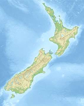 Location of Te Uku Wind Farm in New Zealand | |
| Country | New Zealand |
| Location | Te Uku, near Raglan |
| Coordinates | 37°52′42″S 174°57′47″E / 37.87833°S 174.96306°ECoordinates: 37°52′42″S 174°57′47″E / 37.87833°S 174.96306°E |
| Status | Operational |
| Construction began | October 2010 |
| Commission date | 19 November 2011 |
| Construction cost | $230m |
| Owner(s) | Meridian Energy and New Zealand |
| Wind farm | |
| Type | Onshore |
| Avg. site elevation | 500m |
| Site area | 200 hectares (2.0 km2) |
| Hub height | 80 m (262 ft) |
| Rotor diameter | 101 m (331 ft) |
| Rated wind speed | 14–90 km/h (9–56 mph) |
| Power generation | |
| Units operational | 28 |
| Make and model | Siemens: SWT-2.3-101[1] |
| Nameplate capacity | 64 MW |
|
Website https://www.meridianenergy.co.nz/about-us/te-uku/ | |
Te Uku Wind Farm is a wind farm at Te Uku near Raglan, New Zealand. It has a capacity of 64MW[2][3] using 28 wind turbines. Construction was completed in March 2011,[4] at a cost of $200 million.[5] The farm covers an area of approximately 200 hectares (2.0 km2).[6] The wind farm is jointly owned by WEL Networks and Meridian Energy.[7]
Resource consent was granted in May 2008[8] and appeals were resolved by November 2008. Construction of the wind farm began in 2010.[9] Hick Bros Civil and Spartan Construction won an award for outstanding technical and environmental planning.[10] The wind farm was officially opened by the Prime Minister in February 2011.[11] Te Uku was fully operational on 10 March 2011.[12]
Te Uku Windfarm is controlled from Twizel.[13]Twizel control centre was set up for the Waitaki power scheme.
The windfarm is linked to the national grid's Te Kowhai substation by about 17 km (11 mi) of 33kv lines on 159[14] steel poles built on concrete pile foundations[15] and an underground cable from just west of Waitetuna Valley Rd to Cogswell Rd,[16] a total of about 25 km (16 mi).[17]
Construction
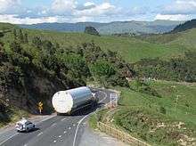
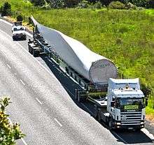
Each 130.5 m. high, 318 tonne, turbine took 2 or 3 days to build using 4 cranes, the largest a 600 tonne KR Wind/NZ Crane Group Alliance crane. Towers were formed in 3 sections (made in Korea), and topped by Siemens components (as at Makara) - a 3.5 m circumference, 81 tonne nacelle, hub and 3 turbine blades. Barge transport was considered, but rejected in favour of road transporters running from September 2010 to January 2011.[18]
Pipiwharauroa Way
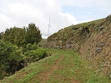

One of the mitigation measures was this walking and cycling track. The track climbs from a car park on Kawhia Rd, near Bridal Veil, runs about 6 km and climbs 280m to the windfarm on Wharauroa Plateau. Over 2 km of less interesting walking can be saved if the walk is started from the gate at the end of the driveable part of Plateau Rd. From this point Lake Disappear can be seen to the south after wet weather. There is no marked end to the track. It just peters out into the partly formed paper road (see the dashed line on the 1:50,000 map just north of the Pakihi Stream). It follows an ancient Maori track which was often used by warriors on raids between Waikato and Kawhia.[19]
The road access to the windfarm largely followed the paper road, which was started around 1900 (a local historian wrote that a store ledger started at Te Mata in 1896 includes at least 11 workers on the road[20]) and seemingly abandoned a few years later, though Bob Vernon also wrote, "about 1919 the Public Works Department cut a six-foot track through solid bush, from the south-eastern end of the plateau [where it joins this paper road] to the head of the Makomako valley".[21]
In 2013 there was controversy between a local farmer and Waikato District Council about whether Pipiwharauroa Way could be closed for the lambing season.[22]
Microwave tower

From the mid 1950s a microwave tower has been on the crest of the hill overlooking Te Uku.[23] It is now also part of a smart metering network.[24] There is also a VHF repeater near the tower.[25]
See also
- List of power stations in New Zealand
- Wind power in New Zealand
- Pakoka River - photo of wind farm and item on mitigation work.

References
- ↑ http://www.siemens.com/press/en/pressrelease/press=/en/pressrelease/2009/renewable_energy/ere200911019.htm
- ↑ "Project Te Uku". Meridian Energy.
- ↑ "Introduction and fact sheet". WEL Networks. Retrieved 2008-09-23.
- ↑ "Gala Day Celebrates Completion Of Te Uku Wind Farm" (Press release). Meridian Energy. 23 March 2011.
- ↑ Bradley, Grant (16 October 2009). "Meridian Energy to build 64 megawatt Raglan wind farm". NZ Herald.
- ↑ "WEL wind park resource consent application" (PDF). WEL Networks Ltd. Retrieved 2008-09-21.
- ↑ "Wind Park Update" (PDF). WEL Networks Ltd. 2008-09-17. Retrieved 2008-09-23.
- ↑ "Wind farm bid a winner". Waikato Times. 2008-05-30. Retrieved 2008-09-21.
- ↑ "First turbine goes up at Te Uku wind farm" (Press release). Meridian Energy. 3 November 2010. Retrieved 5 November 2010.
- ↑ "Hick Bros & Spartan pick up prize for building Te Uku Wind Farm". Raglan 23. Retrieved 14 December 2014.
- ↑ Holloway, Bruce (10 February 2011). "PM blown away by wind farm". Retrieved 13 February 2011.
- ↑ "Construction of Te Uku wind farm complete" (Press release). Meridian Energy. 31 March 2011. Retrieved 3 April 2011.
- ↑ undefined
- ↑ "Raglan Chronicle". Issuu. 30 July 2010. Retrieved 2015-12-09.
- ↑ "Wind Farm Electricity Generation: Edison". www.edison.co.nz. Retrieved 2015-12-09.
- ↑ "WEL Networks western upgrade". www.raglan23.co.nz. Retrieved 2015-12-09.
- ↑ "John key opens Te Uku Wind Farm". www.raglan23.co.nz. Retrieved 2015-12-09.
- ↑ "First Turbine Goes Up At Te Uku Wind Farm". Raglan 23. Retrieved 14 December 2014.
- ↑ page 76 Raglan County Hills and Sea: A Centennial History 1876-1976 - C. W. Vennell, Susan Williams - Google Books. Books.google.co.nz. Retrieved 2012-12-18.
- ↑ Te Mata - Te Hutewai the Early Days R. T. VERNON 1972 A. O. RICE LIMITED
- ↑ Te Mata, Aotea. Retrieved 14 December 2014.
- ↑ Raglan Chronicle. "ISSUU - Raglan Chronicle by Raglan Chronicle". Issuu. Retrieved 14 December 2014.
- ↑ Te Uku microwave mast on 1:50,000 map
- ↑ Aprisa XE and Aprisa SR empower robust, reliable, digital multi-service network
- ↑ Raglan23: Te-Uku part of new amateur radio network December 17, 2014
External links
- Te Uku Wind Farm at WEL Networks - refers to 25 km transmission line to link with grid
- Siemens turbine brochure
- Pipiwharauroa Way on Raglan23 website
- The towers are made of steel, not concrete. And are only 80 meters tall, with 49m blades, making a total of 130m.[1]
- Tranzcarr Heavy Haulage with photos of the transport of the towers from Auckland
| Operating power stations |
|  | ||||||||||||||||||||||
|---|---|---|---|---|---|---|---|---|---|---|---|---|---|---|---|---|---|---|---|---|---|---|---|---|
| Companies | ||||||||||||||||||||||||
| Wind power | ||
|---|---|---|
| Wind turbines | ||
| Wind power industry | ||
| Wind farms | ||
| Concepts | ||
- ↑ "Te Uku Wind Farm". www.windenergy.org.nz. Retrieved 2015-12-09.