Tejon Pass
| Tejon Pass | |
|---|---|
|
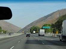
The top of the Tejon Pass on Interstate 5 | |
| Elevation | 4,160 ft (1,268 m) |
| Traversed by |
|
| Location | Los Angeles and Kern counties, California |
| Range | Tehachapi Mountains |
| Coordinates | 34°48′11″N 118°52′37″W / 34.80302°N 118.87707°WCoordinates: 34°48′11″N 118°52′37″W / 34.80302°N 118.87707°W |

The Tejon Pass (pronounced "tay-HONE, tuh-HONE, or TAY-hone), previously known as Portezuelo de Cortes, Portezuela de Castac, and Fort Tejon Pass, is a mountain pass between the southwest end of the Tehachapi Mountains and northeastern San Emigdio Mountains, linking Southern California north to the Central Valley. It has been traversed by major roads such as the El Camino Viejo, the Stockton – Los Angeles Road, the Ridge Route, U.S. Route 99, and now Interstate 5.
Geography
The highest point of the pass is near the northwestern-most corner of Los Angeles County, north of Gorman. Its highest point is 4,144 feet (1,263 m)[1] or 4,160 feet (1,270 m) [2] (the difference arises from the altitudes of Interstate 5, and both Peace Valley Road and Gorman Post Road that run next to the freeway at the pass' apex, respectively), 75 miles (121 km) northwest of downtown Los Angeles and 47 miles (76 km) south of Bakersfield.
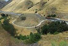
The route of Interstate 5 winds through Tejon Pass (the highway's highest point in the state), connecting the southern part of the state with the San Joaquin Valley and the north.
The pass has a gradual rise from its southern approach of 1,362 feet (415 m) at Santa Clarita,[3] but a precipitous descent through Grapevine Canyon toward the San Joaquin Valley on the north, where it ends at Grapevine at 1,499 feet (457 m).[4]
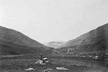
On its northward slope lies Fort Tejon State Historic Park, the site of a former U.S. Army post, first garrisoned on August 10, 1854.[5]
History
Pre-Columbian
Historians speak of the area around Gorman, California (just south of the crest of the Tejon Pass), as "one of the oldest continuously used roadside rest stops in California." This is because pre-Columbian indigenous Californians "would have stopped there when it was the Tataviam village of Kulshra'jek", a trading crossroads for hundreds to thousands of years.[6]
18th century
In 1772, Lieutenant Pedro Fages crossed the pass in pursuit of military deserters, and named it Portezuelo de Cortes (Cortes Pass).[7][8][9] Fages also named the canyon beyond the pass leading down into the Tulare Basin, Cañada de las Uvas (Canyon of the Grapes) for all the grape vines growing in it.[10]
In the late 18th century, El Camino Viejo, a road between Los Angeles and the Mission Santa Clara de Asis began to be used for travel north and south along the western San Joaquin Valley. It crossed over the pass and turned westward up Cuddy Canyon and then down San Emigdio Creek into the San Joaquin Valley.
Old Tejon Pass
In 1806, Father Jose Maria Zalvidea, diarist for the expedition of First Lieutenant Francisco Ruiz into the San Joaquin Valley, named the canyon, creek, and pass which had been discovered in 1776 by the explorer priest, Father Francisco Garces. He recorded the name as "Tejon" (badger)—after a dead badger found at the canyon's mouth. This original Tejon Pass (later called "Old Tejon Pass"), was situated 15 miles to the northeast of what is now Tejon Pass. The old pass went through the Tehachapi Mountains, at the top of the divide between Tejon Creek Canyon in the San Joaquin Valley and Cottonwood Creek Canyon in Antelope Valley.[11]
Before 1854, the main route of travel into the San Joaquin Valley had come directly north from Elizabeth Lake (originally Laguna de Chico Lopez) across the Antelope Valley, over this original Tejon Pass, and down into Tejon Canyon, and then proceeded west along Tejon Creek—into the lands of the Rancho Tejon, that had been granted in 1843. This route to the pass diverted from the El Camino Viejo at Elisabeth Lake, and from 1849 to before 1854 it was the main road connecting the southern part of the state to the trail along the eastern side of the San Joaquin Valley to the goldfields to the north.[12]
19th century
Castaic Pass
In 1843, Rancho Castac was established in La Cañada de las Uvas. During that same year, the first grant of Rancho Los Alamos y Agua Caliente included the pass, which was now called Portezuela de Castac (Castaic Pass).[13]
Fort Tejon Pass
After the establishment of Fort Tejon and the Stockton - Los Angeles Road, the Portezuela de Castac began to be called the "Fort Tejon Pass." The rather poor wagon route of the old Tejon Pass route was generally abandoned, and eventually the Fort Tejon Pass took the shortened name it has today.[14]
In 1858 the Butterfield Overland Mail stagecoach line ran through the pass on the Stockton - Los Angeles Road. The Butterfield Overland was discontinued in 1861 but was replaced by the Telegraph Stage Line, which stopped at almost all the former stations, including Gorman's, where the horses were changed. Six of them were used for the pull up from Bakersfield to Gorman's.[15]
20th century
The Ridge Route was the first automobile highway linking the Central Valley with the Los Angeles Basin. It was laid in a sinuous fashion through the ridges and gullies of the Sierra Pelona Mountains to the Tejon Pass around 1910. The northern portion of this highway, which became a part of U.S. Route 99, was known as "The Grapevine." The Ridge Route was replaced by a three-lane alternate highway in 1933, a four-lane expressway in 1947, and later by the eight-lane Interstate 5 Freeway in 1970.[16]
Weather concerns
The pass is sunny in the summer, spring, and fall, but is subject to severe weather and closure to traffic in the winter. The 40-mile stretch of Interstate 5 between Grapevine and Castaic is sometimes closed by the California Highway Patrol,[17] generally because of the icy conditions combined with the steep grade of the pass, and the high traffic during the winter holidays.[18] The Highway Patrol is also concerned, especially with the number of big-rigs that pass through, that one accident in the snowy conditions might force traffic to slow down or come to a complete stop, leaving hundreds of vehicles stalled at once.[19] Whenever there is such a closure, traffic must either wait for it to reopen, or endure a multi-hour detour running between Bakersfield and Los Angeles via CA 58.[20]
Communities
This historic gap has given its name to the Mountain Communities of the Tejon Pass. Beginning on the south at Santa Clarita, it passes through Castaic, Gorman, and Lebec, to end at Grapevine. It skirts the Tejon Ranch, where two large planned communities—Centennial and Tejon Mountain Village—are proposed.
See also
- Tehachapi Pass, used by the rail lines connecting southern and northern California.
References
- ↑ Virtual tour of U.S. 99
- ↑ U.S. Geographic Names Information System, No. 274055
- ↑ U.S. Geographic Names Information System, No. 2411819
- ↑ U.S. Geographic Names Information System, No. 1660696
- ↑ Fort Tejon State Historic Park website
- ↑ Santa Clarita Valley in Pictures; Kane, Bonnie Ketterl; "A History of Gorman"; March 2002.
- ↑ The Trail to Kashtiq; Johnson, John R.; Journal of California Anthropology, Winter 1978: Vol. 5, No. 2; pp. 188-198; Note 9; Quote: "The origin of this name can be traced back to Pedro Fages, who became California's first governor. In 1772, he was the first official Spanish visitor to enter the southern San Joaquin Valley. He called Tejon Pass the Portezuelo de Cortes, apparently with an eye towards political considerations in Mexico."
- ↑ Bolton, Herbert E.; In the South San Joaquin Ahead of Garcés; quarterly publication of the California Historical Society, Vol 10, 1931, pp.210-219;
- ↑ Earle Crowe, "Men of El Tejon," Ward Ritchie Press, Los Angeles, 1957, p.22)]
- ↑ The Ridge Route: the Long Road to Preservation; Scott, Harrison Irving; "The California Historian," www.californiahistorian.com website, accessed November 14, 2011; Quote: "The first white man through this area was a Spanish officer and acting governor of Alta California in 1772, Don Pedro Fages. He noticed an abundance of Cimarron grapes growing wild in the area north of what is now Gorman. He named the place Canada de Las Uvas, or Grapevine Canyon. Grapevines were so prevalent the wagoneers and soldiers had to hack their way through. Wild grapes still grow on the sides of I-5 in the pass." [sic]
- ↑ The Ridge Route: the Long Road to Preservation; Scott, Harrison Irving; "The California Historian," www.californiahistorian.com website, accessed November 14, 2011; Quote: "The name Tejon originated during an expedition in 1806 from the Santa Barbara Mission into the San Joaquin Valley led by Lieutenant Francis Ruiz. His diarist, Father Jose Maria Zalvidea, first recorded the word tejon to designate the area... the name Tejon formerly belonged to this other pass 15 miles further east."
- ↑ Where Rolls the Kern: a History of Kern County, California; Herbert G. Comfort; Enterprise Press; Moorpark, Ca; 1934; (#255); Chapter IV, "The Founding of Fort Tejon; pp. 21-52. "Before 1854, the main line of travel into the valley was straight North from Elizabeth Lake across Antelope Valley, entering the San Joaquin by way of the original Tejon Pass, at the head of Tejon Creek, above the present headquarters of Tejon Rancho. The establishment of the Fort Diverted this general travel to the West almost 29 miles to the present Tejon Pass, then known as Fort Tejon Pass. As the Tejon Creek Pass was abandoned, the name Tejon Pass came to be used solely for the pass leading into Canada de las Uvas."
- ↑ Diseño del Rancho Los Alamos y Agua Caliente, Calif.; por Esteban Ardisson; from UC Berkeley; Bancroft Library
- ↑ The Ridge Route: the Long Road to Preservation; Scott, Harrison Irving; "The California Historian," www.californiahistorian.com website, accessed November 14, 2011; Quote: "The name Tejon formerly belonged to another pass 15 miles further east. Lieutenant Robert Stockton Williamson of the Pacific Railroad surveyed the area in 1853. His party crossed the Tehachapis by "one of the worst roads he ever saw." Hearing of a better road further west, he scouted it and found it would be far more practicable for wagons if the bulk of the traffic henceforth went that way. The name Tejon was transferred west to today's "Tejon Pass."
- ↑ Frank F. Latta, Saga of Rancho El Tejón, Santa Cruz, California: Bear State Books, 1976.
- ↑ The Ridge Route: the Long Road to Preservation; Scott, Harrison Irving; "The California Historian," www.californiahistorian.com website, accessed November 14, 2011; Quote: "There have been three Ridge Route highways. The 1915 highway...; the 1933 three-lane Ridge Alternate Highway identified as Highway 99 (in 1947 converted to a 4-lane expressway); and today's 8-lane I-5 freeway completed in 1970."
- ↑ "Grapevine closed by snow: playtime near L.A., but tough work on I-5". Christian Science Monitor. 2011-01-03. Retrieved 2011-01-23.
[Highway Patrol Officer John Lutz] adds that the Highway Patrol regards this short-term closure as routine: "This happens nearly every year"
- ↑ "Motorists criticize weather-related closure of the 5 Freeway in the Grapevine". Los Angeles Times. 2011-01-05. Retrieved 2011-01-23.
the California Highway Patrol on Tuesday strongly defended its decision to cut traffic off, saying that the icy road surface, steep grade of the Tejon Pass and heavy post-holiday traffic volume made the Grapevine simply too dangerous to navigate.
- ↑ "Motorists criticize weather-related closure of the 5 Freeway in the Grapevine". Los Angeles Times. 2011-01-05. Retrieved 2011-01-23.
If an accident forces traffic to slow or come to a complete stop, and snow continues to fall, hundreds of vehicles can become stalled at once. The Tejon Pass is particularly vulnerable because of its steep hills and the number of big-rigs that travel on it
- ↑ Grapevine Closures: It's for Our Own Good; Jorge Barrientos; "The Bakersfield Californian," December 20, 2008.
External links
| Wikimedia Commons has media related to Tejon Pass. |
- history-map.com; See Map and profile of the Tejon Pass: from explorations and surveys / made under the direction of the Hon. Jefferson Davis, Secretary of War by Lieut. R. S. Williamson, Topl. Engrs. assisted by Lieut. J. G. Parke, Topl. Engrs. and Mr. Isaac Williams Smith, Civ. Engr., 1853.