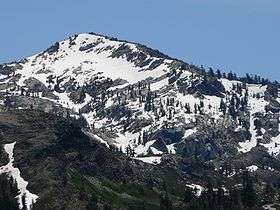
Tells Peak
| Tells Peak | |
|---|---|
 | |
| Highest point | |
| Elevation | 8,876 ft (2,705 m) NAVD 88[1] |
| Prominence | 272 ft (83 m) [1] |
| Listing | Tahoe OGUL Peak List[2] |
| Coordinates | 38°57′36″N 120°15′16″W / 38.9599073°N 120.2543576°WCoordinates: 38°57′36″N 120°15′16″W / 38.9599073°N 120.2543576°W [3] |
| Geography | |
| Location | El Dorado County, California, U.S. |
| Parent range | Sierra Nevada |
| Topo map | USGS Loon Lake |
| Climbing | |
| Easiest route | Scramble, class 2[2] |
Tells Peak is a mountain in the Sierra Nevada at the very north end of the Crystal Range (California), to the west of Lake Tahoe. It is located in the Desolation Wilderness in El Dorado County, California.
The origin of the name is not certain. It is probably named for a Swiss homesteader named Tell who lived a few miles to the west. At least one historian believes it was named for Ciperano Pedrini, a storekeeper in Garden Valley, who was known as Bill Tell.[4]
References
- 1 2 "Tells Peak, California". Peakbagger.com.
- 1 2 "Tahoe OGUL Peak List". Western States Climbers.
- ↑ "Tells Peak". Geographic Names Information System. United States Geological Survey.
- ↑ Gudde, Erwin G. (1949). California Place Names. Berkeley: Univ. of California Press. p. 357.
External links
- "The Crash of the B-17C near Tells Peak, CA". Check-Six.com. Retrieved 2009-08-22.
This article is issued from Wikipedia - version of the 12/26/2015. The text is available under the Creative Commons Attribution/Share Alike but additional terms may apply for the media files.