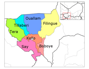
Téra Department
| Téra | |
|---|---|
| Department | |
 Tera Department location in the region | |
| Country |
|
| Region | Tillabéri Region |
| Area | |
| • Total | 15,794 km2 (6,098 sq mi) |
| Population (2011) | |
| • Total | 579,658 |
| Time zone | GMT 1 (UTC+1) |
Téra is a department of the Tillabéri Region in Niger. Its capital lies at the city of Téra. As of 2011, the department had a total population of 579,658 people.[1]
History
Téra Department covers most of the historic territory of Liptako. Today primarily a home to speakers of the Southern Songhai language, prior to the Songhai Empire, the area was populated by Gourmantche and Mossi peoples. By the 16th century Tera was one of the many small states which survived the destruction of the Songhai Empire, with many Songhai communities resettling into what is today Niger from the north. The Dendi Songhai state of the 17th century ruled the area, before dividing into several small states, each ruled by an Askia of Songhai noble lineage. In the late 19th century, the Songhai city state around Tera was in almost continual conflict with Tuareg groups in the north and east, with the city of Tera sacked and destroyed as late as 1885. Forces from Usman dan Fodio's Sokoto Caliphate took the area several times in the early 19th century as well, but were pushed back by Djerma forces in the regions to the southeast, though semi-nomadic Fula communities were present in the area from at least the 18th century.
Population
With a majority of Songhai - Djerma peoples, large Fula, Gourmantche and Buzu populations live in the area as well. Tera is one of the few places where the Kaado Southern Songhay dialect is still spoken, although peoples are more likely to call themselves (and their language) "Songhay" or "Zarma".[2]
Geography
The Tera department slopes down to the east, bordered by the Niger River. To the west, the area laterite plateaus broken by occasional mesas. Tera Department lies entirely within the Sahel region, and receives between 400mm-500mm of rain a year. The vegetation is sparse, with dry scrub forests and grasses, except in the land along the Niger River, which is lush with wild vegetation as well as vegetable and fruit gardens. In the northern section of Tera Department the Niger River forms a broad channel, where Hippopotamus and other wildlife are still common.
The Kokoro and Namga Wetlands in Tera Department was designated a Ramsar site in 2001. Covering 668km2 the wetland hosts migratory birdlife and is important to the local ecology.[3]
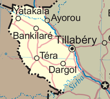
The Departmental seat, a town of almost 20,000, lies on a tributary of the Niger, dammed to provide a small lake. Its main tarred road—the RN4—passes south from Tera to Diagourou (a Fula town 15 km away), Dargol and Gotheye, crossing the Niger at Bac Farie by ferry. The RN1 road continues to Niamey, 180 km from Tera. To the north of the department lie the small towns of Yatakala, Labezanga (where the Niger crosses to Mali), Bankilare (a mainly Tuareg town) and Kokoro in the center of the department. The cities of Ayorou and Tillaberi lie just across the Niger in Tillaberi Department to the east.
The department is bordered to the south by Say Department and Kollo Department, along the course of the Sirba River, a seasonal tributary of the Niger.
Economy
Most of the population is engaged in agriculture, with Millet being the primary crop.
The area contains a major road connecting Niger with Dori Burkina Faso, making Tera a transport and trade hub.[4] Tera also has an airport, a 3900 ft/1189m strip designated DRRE.[5]
The Samira Hill Gold Mine (Namaga concession) began producing gold in 2004 from the Tera greenstone belt which surrounds Koma Bangou, the country's largest artisanal mining site. The mine is operated by SML (Societe des Mines du Liptako), a joint venture between Moroccan Societe SEMAFO Inc and Canadian ETRUSCAN, along with a Nigerien 20% stake.[6]
The traditional and distinctive Tera-Tera fabric is produced by Djerma artisans in Tera. Strips of striped, dyed handloomed fabric are sewn into larger blankets and are used in traditional marriage ceremonies and exported abroad.[7]
Contested international border
Prior to 1910, portions of what are now Ansongo Mali were administered from Tera, while prior to 1922, Dori in modern Burkina Faso was administered from Tera, as part of the Niger colonial military territory of French West Africa.[8] When the French divided French Upper Volta colony between its neighbors in 1932, the districts of Fada and most of Dori (excluding the canton of Aribinda) were added to Niger, most in the (then) Cercle of Tera. Upper Volta was reconstituted in 1946, but the Tera Cercle's boundary remained a source of dispute until the Niger-Upper Volta protocol of agreement on their common boundary was signed at Niamey on June 23, 1964, fixing the present western border of the Tera administrative entity.[9]
References
- ↑ "Annuaires_Statistiques" (PDF). Institut National de la Statistique. Retrieved 2 May 2013.
- ↑ Southern Songhay Speech Varieties In Niger A Sociolinguistic Survey of the Zarma, Songhay, Kurtey, Wogo, and Dendi Peoples of Niger, Performed by Byron & Annette Harrison and Michael J. Rueck with Mahaman Soumana as Interpreter January - March 1997
- ↑ Kokoro and Namga wetlands, Niger, Ulf Liedén, Lieden.net, 2008. Includes a travel diary and photographs.
- ↑ Burkina Faso, Niger: Route Dori (Burkina)-Tera (Niger). 21.02.2008, African Development Bank/EVD International road project details.
- ↑ Aircharter Guide: Niger Airports with Charter Aircraft
- ↑ Carlin Resources - Significant gold assays from Tera Project- Niger Business Wire, April 1, 1997
Gold and Uranium Exploration in Republic of Niger, West Africa, March 2007. - ↑ COMMITTEE FOR THE IMPLEMENTATION OF TEXTILE AGREEMENTS, Determination under the African Growth and Opportunity Act December 18, 2006. Committee for the Implementation of Textile Agreements (CITA), United States Department of Commerce, International Trade Administration.
- ↑ International Boundary Study No. 150 – January 13, 1975 Mali – Niger Boundary (Country Codes: ML-NG) Office of the Geographer, Bureau of Intelligence and Research, Department of State, United States of America.
- ↑ International Boundary Study No. 146 – November 18, 1974 Burkina Faso (Upper Volta) – Niger Boundary (Country Codes: UV-NG) Office of the Geographer, Bureau of Intelligence and Research, Department of State, United States of America.
- James Decalo. Historical Dictionary of Niger. Scarecrow Press/ Metuchen. NJ - London (1979) ISBN 0-8108-1229-0
- Finn Fuglestad. A History of Niger: 1850-1960. Cambridge University Press (1983) ISBN 0-521-25268-7
- Jolijn Geels. Niger. Bradt UK/ Globe Pequot Press USA (2006) ISBN 978-1-84162-152-4
- Portions of this article were translated from the French language Wikipedia articles fr:Tillabéri (région) and fr:Téra (département). 2008-06-20
Further reading
- Hammadou Soumalia. Traditions des Songhay de Tera, Niger (Hommes et sociétés) Editions Karthala, Niger (1998)
External links
- Photographs and family stories of students from Tera at Africa Speaks: Life Stories (1998)
- Worldvision and Islamic Relief projects in Tera during the 2004 famine.
- Catholic Relief Services Tera project, working with sesame farming.
- brighton2capetown:Niger. Story and photos of a trip through Tera on motorcycle.
Capital: Niamey in Niamey Capital District | |
| Agadez Region | |
| Diffa Region | |
| Dosso Region | |
| Maradi Region | |
| Tahoua Region | |
| Tillabéri Region | |
| Zinder Region | |
Coordinates: 14°00′38″N 0°45′11″E / 14.01056°N 0.75306°E