Teton Glacier
| Teton Glacier | |
|---|---|
|
Teton Glacier at bottom is to the right of Grand Teton and left of Mount Owen | |
 Teton Glacier | |
| Type | Mountain glacier |
| Coordinates | 43°44′31″N 110°47′35″W / 43.74194°N 110.79306°WCoordinates: 43°44′31″N 110°47′35″W / 43.74194°N 110.79306°W[1] |
| Area | 53 acres (0.21 km2) |
| Length | .66 mi (1.06 km) |
| Terminus | Moraine |
| Status | Retreating |
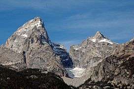
Teton Glacier is a mountain glacier located below the north face of Grand Teton in Grand Teton National Park, Wyoming, United States. Its neighbors are Mount Owen to the west and Teewinot Mountain to the north.[2] Teton Glacier is the largest of the twelve named glaciers in the park. In 1971, the glacier was approximately 3,500 ft (1,100 m) long and 1,100 ft (340 m) wide.[3] Between 1967 and 2006, Teton Glacier lost approximately 14 to 20 percent of its surface area, a reduction from 64 to 53 acres (26 to 21 ha).[4]
References
- ↑ "Teton Glacier". Geographic Names Information System. United States Geological Survey. Retrieved 2012-08-12.
- ↑ Grand Teton, WY (Map). TopoQwest (United States Geological Survey Maps). Retrieved 2012-08-12.
- ↑ Love, J.D.; John C. Reed, Jr (1971). "Creation of the Teton Landscape". National Park Service. Retrieved 2013-02-15. Cite uses deprecated parameter
|coauthors=(help) - ↑ Edmunds, Jake; et al. (February 2012). "Glacier Variability (1967-2006) in the Teton Range, Wyoming, United States". Journal of the American Water Resources Association. 48 (1): 187–196. doi:10.1111/j.1752-1688.2011.00607.x. Retrieved 2013-02-15.
See also
This article is issued from Wikipedia - version of the 6/15/2016. The text is available under the Creative Commons Attribution/Share Alike but additional terms may apply for the media files.