Thénia
| Thénia | |
|---|---|
 | |
 | |
 Thénia | |
| Coordinates: 36°43′40″N 3°33′14″E / 36.72778°N 3.55389°ECoordinates: 36°43′40″N 3°33′14″E / 36.72778°N 3.55389°E | |
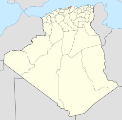
| Country | Algeria |
| Province | Boumerdès |
| Elevation | 301 m (988 ft) |
| Population (1998)[1] | |
| • Total | 19,078 |
| Time zone | West Africa Time (UTC+1) |
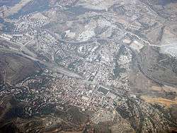
Thénia (sometimes incorrectly written as Thenia), with around 40,000 inhabitants, is the chief town in the daïra of the same name, in the wilaya of Boumerdès, in Kabylie in northern Algeria. The name derives from the Berber phrase Tizi n At Aycha (via the Arabic, Theniet Beni Aicha), which means "the mountain pass of the Aycha tribe"—the prefix "At" means "tribe" in Berber. The steep-sided pass, which is only about 800 metres wide at its narrowest point, marks the transition between the Mitidja and the Grande Kabylie.[2]
Geography
Thénia is located on the main road from Algiers to Constantine, about forty kilometres east of Algiers, about ten kilometres inland from the coast, at an altitude of 300 metres—an excerpt from the 1962 Michelin map of Algeria showing the location can be seen here. Between the town and the coast, the scrub-covered Djebel bou Arous rises to a height of around 400 metres and then falls more gently to the coast. South and east is the valley of the Oued Isser, whose sides rise to around 600 metres and are deeply incised by streams; in many places the slopes are covered with vineyards and olive-groves.
History
During the French occupation, the town was renamed Ménerville, after Charles-Louis Pinson de Ménerville (1808-1876), the first president of the court of appeals in Algiers.[3] It resumed the name of Thénia a few years after independence in 1962.
In 1944, the town had 2,656 inhabitants, of which the majority, 1,929, were European pieds noirs while the commune or district had 12,755, of which 2,640 were pieds noirs.[2]
Thénia was very near to the offshore epicenter of the May 21, 2003 Boumerdès earthquake, the strongest quake to hit Algeria since 1980.[4]
At least four people were killed and around twenty injured by a car bomb outside a police station in the town on 29 January 2008.[5]
References
- ↑ Statoids
- ↑ "Algérie - Ménerville".
- ↑ Curtis L. Edwards, ed. (2004). Zemmouri, Algeria, Mw 6.8 Earthquake of May 21, 2003. Reston, VA: ASCE, TCLEE. ISBN 9780784407462.
- ↑ Mustapha Benfodil (2008-02-09). "Thénia, dellys et naciria : dans l'épicentre de la terreur". El Watan.