Tha Pho, Phitsanulok
| Tha Pho ท่าโพธิ์ (English: Bo-Tree Dock) | |
|---|---|
| Tambon | |
|
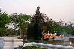
Statue of King Naresuan the Great in Naresuan University | |
| Amphoe | Mueang Phitsanulok |
| Province | Phitsanulok |
| Country | Thailand |
| Population (2005) | |
| • Total | 9,626 |
| Time zone | Thailand (UTC+7) |
| Postal code | 65000 |
| Geocode | 650106 |
| Chief watercourse | Nan River |
| Website | ThaiTambon.com |
Tha Pho (Thai: ท่าโพธิ์) is a subdistrict in the Mueang Phitsanulok District of Phitsanulok Province, Thailand.
Geography
The topology of Tha Pho is flat lowlands.[1] The subdistrict is bordered to the north by Tha Thong, to the east by Bueng Phra, to the south by Wat Phrik and to the west by Amphoe Bang Rakam.[1] Tha Pho lies within the Nan Basin, which is part of the Chao Phraya Watershed. The Nan River flows through the subdistrict.[1]
Administration
The following is a list of the subdistrict's muban, which roughly correspond to the villages:[2]
| No. | English | Thai |
| 1 - 2 | Ban Wang Somsa | บ้านวังส้มซ่า |
| 3 | Ban Wang Won | บ้านวังวน |
| 4 | Ban Khlong Khu | บ้านคลองคู |
| 5 - 6 | Ban Yang En | บ้านยางเอน |
| 7 | Ban Tha Pho | บ้านท่าโพธิ์ |
| 8 | Ban Kaek | บ้านแขก |
| 9 | Ban Khlong Nong Lek | บ้านคลองหนองเหล็ก |
| 10 | Ban Hua Krathing | บ้านหัวกระทิง |
Infrastructure
Economy
The economy is based on rice farming and other agriculture.[1]
Education
Naresuan University
Naresuan University (abbreviated as Mor Nor for Mahawithayalai Naresuan) is located in Tha Pho.[1] The university is named after King Naresuan the Great, and the campus contains a large statue of him.
Primary schools
The following is a list of primary schools in Tha Pho:[1]
- Wat Sakat Namman School
- Wat Yang En School
- Wat Khung Wari School
- Ban Khlong Nong Lek School
Kindergartens
The following is a list of kindergartens (nursing care) in Tha Pho:[1]
- Faculty of Nursing Naresuan University Nursery
- Ban Wang Won Nursing care
- Ban Yang En Nursing care
- Ban Wang Somsa Nursing care
- Ban Khlong Nong Lek Nursing care
- Ban Khung Wari Nursing care
Hospitals
- Naresuan University Hospital is the super tertiary care hospital in lower northern region of Thailand.
Temples
- Wat Yang En
- Wat Sakat Namman
- Wat Khung Wari
- Wat Chaem Suwan
References
- 1 2 3 4 5 6 7 ThaiTambon.com
- ↑ Pitlocal.org (in Thai)