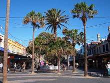
The Corso, Manly

The Corso is one of the main streets of Manly, New South Wales, Australia. It connects the Manly ferry wharf and Sydney Harbour, to the Pacific Ocean side of the Manly peninsula. It is named after the Via del Corso in Rome.
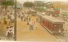
There has long been a track between Manly Cove and Ocean Beach, worn by the local Aboriginal people, the Kay-ye-my clan of the Guringai people. Proposed by Henry Gilbert Smith, the earliest developer of Manly, and initially built as a boardwalk in 1855, the street allowed tourists to cross the sand spit between the harbour pier and ocean beach. By the 1920s the Corso was the main shopping precinct of the Northern Beaches.[1]

The Corso was partially returned to a pedestrian street in the 1970s. Its ocean-side intersection marks the boundary between the North Steyne and South Steyne sections of Manly beach.
See also
References
- ↑ MacRitchie, John. "The Corso". Dictionary of Sydney. Retrieved 2 July 2014.
External links
| Wikimedia Commons has media related to The Corso, Manly. |
- The Corso at the Dictionary of Sydney by John MacRitchie, 2008. [CC-By-SA]
- The Corso Community Precinct
- The Corso Manly artefact catalogue at Research Data Australia, published by the Australian National Data Service.
Coordinates: 33°47′52″S 151°17′13″E / 33.797780°S 151.286875°E