The Water Tower, Kenilworth
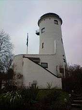
The Water Tower is a building in Kenilworth, Warwickshire, England. In the mid 20th century it was nicknamed 'Kenilworth Lighthouse', though the name has now fallen out of usage.[1] Made of brick, it is 90-foot (27 m) tall and was built by Joseph Lee and John Lamb a haberdasher from Warwick in the mid-18th century, and for the next 76 years was a windmill used to grind the corn for the townsfolk. With the windmill machinery on top now redundant, the tower was adapted to allow an iron water tank of 26,000 US gallons (98,000 l; 22,000 imp gal) to be added. It was Kenilworth's primary water source until 1939, and was used as an auxiliary source until 1964. From the early water storage period time, the only extant photographs display signs advertising Singers Cycles of nearby Coventry on the tank.[2] By 1960 the Water Tower was out of use, and it was decided to sell it off as a private residence.The conversion work began in 1972 and took two years. The work, undertaken by architect Edward Byron, won an award from the United Kingdom Council for European Architectural Heritage.
From the upper floors there are views over the town of Kenilworth and its castle and the tower stands within a few hundred yards of the field known as Parliament Piece where it is reputed Simon de Montfort held the first English Parliament in 1264.
A notable tale involving the windmill from the early 19th century is of a brave local, one Jerry O'Hea who showed his fortitude by grabbing a hold of one of the windmill sails. Unfortunately his arm got caught and he was carried round and round until the miller applied the brake.
Previous residents include businessman Stephen Drucker known chiefly for his role in running the Druckers Vienna Patisserie chain.
References
Coordinates: 52°21′09″N 1°34′34″W / 52.3524°N 1.5761°W