Theodore Roosevelt Dam
| Theodore Roosevelt Dam | |
|---|---|
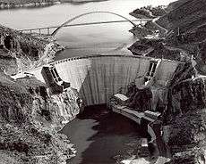
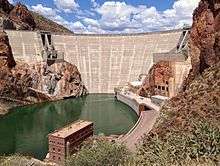 Roosevelt Dam seen from downstream | |
| Country | United States |
| Location | Gila County / Maricopa County, Arizona |
| Coordinates | 33°40′18″N 111°09′40″W / 33.67167°N 111.16111°WCoordinates: 33°40′18″N 111°09′40″W / 33.67167°N 111.16111°W |
| Status | Operational |
| Construction began | 1903[1] |
| Opening date | 1911 |
| Owner(s) | Bureau of Reclamation |
| Dam and spillways | |
| Type of dam | Arch-gravity dam |
| Impounds | Salt River, Tonto Creek |
| Height | 357 ft (109 m) |
| Length | 1,210 ft (369 m) |
| Width (crest) | 21.6 ft (6.6 m) |
| Width (base) | 196 ft (60 m) |
| Dam volume | 606,000 cu yd (463,000 m3) |
| Spillway capacity | 150,000 cu ft/s (4,200 m3/s) |
| Reservoir | |
| Creates | Theodore Roosevelt Lake |
| Total capacity |
1,653,043 acre·ft (2.039×10⁹ m3) (conservation)[2] 2,910,200 acre·ft (3.590×10⁹ m3) (flood control)[3] |
| Catchment area | 5,830 sq mi (15,100 km2) |
| Surface area | 21,493 acres (86.98 km2) (conservation) |
| Power station | |
| Operator(s) | Salt River Project |
| Hydraulic head | 249 ft (76 m) |
| Installed capacity | 36 MW (48,000 hp)[2] |
| Designated | 1963 |
| Delisted | 1999 |
Theodore Roosevelt Dam is a dam on the Salt River located northeast of Phoenix, Arizona. The dam is 357 feet (109 m) high and forms Theodore Roosevelt Lake as it impounds the Salt River. Originally built between 1905 and 1911, the dam was renovated and expanded in 1989-1996. The dam is named after then-President Theodore Roosevelt. Serving mainly for irrigation water supply and flood control, the dam also has a hydroelectric generating capacity of 36 megawatts.
History
One of the original five federal projects authorized on March 14, 1903,[4] under the Newlands Reclamation Act of 1902, Roosevelt Dam was the first major project to be completed under the new federal reclamation program. This, one of the world's highest masonry dam, was started in 1906 and completed in 1911. The beginning of federal production of electric power occurred at Roosevelt Dam when Congress, in 1906, authorized the Reclamation Service to develop and sell hydroelectric power at the Salt River Project.
The Reclamation Act of 1902 created the United States Reclamation Service whose purpose was to design and construct irrigation projects to aid the settlement of the arid west. Previous efforts by individuals and private irrigation companies were inadequate and often unsuccessful. With the creation of the Reclamation Service, the lead role of the federal government in developing large-scale irrigation projects was firmly established.
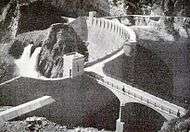
Construction on Roosevelt Dam began in 1903 just below the confluence of Tonto Creek and the Salt River. The primary purpose of the project was to provide water storage for the Salt River Project and flood control through the Salt River Valley. The dam was finished in 1911 after several devastating floods had interrupted the construction progress in 1905. Completed at a cost of $10 million, it was the largest masonry dam in the world for its time with a height of 280 feet (84 m) and a length of 723 feet (216 m), while Roosevelt Lake was for a time the world's largest artificial reservoir. The dam was originally known as "Salt River Dam #1", it was not until 1959 that the dam and reservoir were officially named after Theodore Roosevelt.
Roosevelt Dam, as originally conceived and built, was a symbol of success and a showpiece for the new agency. The dam contributed more than any other dam in Arizona to the settlement of Central Arizona and to the development of large-scale irrigation there. A secondary purpose of the dam was to generate a moderate amount of hydroelectric power. The lake created behind Roosevelt Dam, known as Lake Roosevelt, could hold more than 1,600,000 acre feet (2.0 km3) of water.
The dam was listed as a National Historic Landmark in 1963, but was withdrawn from the list in 1999.[5]
Later expansion
In 1989, an ambitious expansion and renovation project was begun at Roosevelt Dam. The dam was resurfaced with concrete by J.A. Jones Construction Company, and its height was raised 77 feet (23 m) to 357 feet (109 m), which had the effect of increasing the storage capacity of Roosevelt Lake by roughly 20%. This project was completed in 1996 at a cost of $430 million. The $430 million in costs included three other major construction contracts associated with the dam. These included the realignment of Highway 188 over the new Theodore Roosevelt Bridge upstream of the dam, renovations to the hydroelectric power plant, and a tunneling contract known as the "Lake Tap". The Lake Tap contract would provide locations where the penstocks would be located to bring water into the hydroelectric power plant. Shortly after completion, however, the area entered into a prolonged period of drought, and it would be some time before the newly increased capacity was put to use, with the lake finally reaching historic levels of 100% capacity in February 2009.
As a result of the reconstruction, the dam has a completely altered appearance from when it was originally listed as a National Historic Landmark. The original rubble-masonry dam was completely encased in concrete, and the structural height was extended from 280 feet (85 m) to 357 feet (109 m). Since the dam no longer had the integrity of the design, materials, workmanship, feeling, or association that it had when it was originally listed, the National Historic Landmark designation was withdrawn on March 10, 1999. The Theodore Roosevelt Dam National Register District contains other resources that are listed on the National Register of Historic Places, but the dam itself is no longer a contributing property to the district.[5]
Gallery
|


References
- ↑ "General Information". Dam Details - Theodore Roosevelt Dam. United States Bureau of Reclamation. Retrieved 2010-12-29.
- 1 2 "Theodore Roosevelt Dam". Salt River Project. Retrieved 2010-12-29.
- ↑ "Hydraulics and Hydrology". Dam Details - Theodore Roosevelt Dam. United States Bureau of Reclamation. Retrieved 2010-12-29.
- ↑ http://www.waterhistory.org/histories/reclamation/ Overview of the first 5 Reclamation Projects Retrieved on 2015-1-14
- 1 2 "Withdrawal of National Historic Landmark Designation: Roosevelt Dam, Gila and Maricopa Counties, Arizona". Retrieved 2016-11-25.
External links
| Wikimedia Commons has media related to Roosevelt Dam. |
- SRP Water Operations: Theodore Roosevelt Dam
- Historic American Engineering Record (HAER) No. AZ-6-A, "Theodore Roosevelt Dam, Power Plant"
- HAER No. AZ-6-B, "Theodore Roosevelt Dam Transformer House"
- HAER No. AZ-6-C, "Theodore Roosevelt Dam, Eastern Mining Area Transmission Line (115kV System)"
- Roosevelt Dam & The Apache Trail