Tieton Dam
| Tieton Dam | |
|---|---|
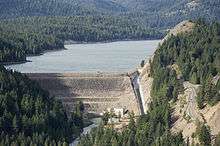 Tieton Dam and Rimrock Lake from Lava Point | |
| Location | Yakima County, Washington, USA |
| Coordinates | 46°39′23″N 121°7′46″W / 46.65639°N 121.12944°WCoordinates: 46°39′23″N 121°7′46″W / 46.65639°N 121.12944°W |
| Opening date | 1925[1] |
| Operator(s) | United States Bureau of Reclamation[1] |
| Dam and spillways | |
| Impounds | Tieton River |
| Height | 319 feet (97 m)[1] |
| Length | 920 feet (280 m)[1] |
| Dam volume | 2,049,000 cu ft (58,000 m3) |
| Reservoir | |
| Creates | Rimrock Lake |
| Total capacity | 203,600 acre feet (0.251 km3)[1] |
| Active capacity | 198,000 acre feet (0.244 km3)[1] |
| Catchment area | 184 square miles (477 km2)[1] |
| Surface area | 2,674 acres (10.8 km2)[1] |
Tieton Dam is an earth and concrete type dam on the Tieton River in Yakima County, in the U.S. state of Washington. The dam began operation in 1925. Its reservoir, Rimrock Lake, has a total capacity of 203,600 acre feet (0.2511 km3) with a normal operating capacity of 198,000 acre feet (0.244 km3) to provides water for agricultural irrigation.[1] This dam is a component of the Yakima Project.[2] Upstream from the dam, the river is impounded by Clear Creek Dam, another element of the Yakima Project. About 8 miles (13 km) downstream from the dam, the Tieton River is tapped for the Tieton Main Canal.
References
- 1 2 3 4 5 6 7 8 9 Tieton Dam, NPDP Dam Directory
- ↑ Bureau of Reclamation. "Project details - Yakima Project". Retrieved 2015-08-18.
External links
![]() Media related to Tieton Dam at Wikimedia Commons
Media related to Tieton Dam at Wikimedia Commons
This article is issued from Wikipedia - version of the 11/30/2016. The text is available under the Creative Commons Attribution/Share Alike but additional terms may apply for the media files.