Tilden Regional Park

Coordinates: 37°53′41″N 122°14′30″W / 37.8946474°N 122.2416352°W[1]
Tilden Regional Park, also known as Tilden Park or Tilden /ˈtɪldən/, is a 2,079-acre (841 ha) regional park in the East Bay, part of the San Francisco Bay Area in California. It is between the Berkeley Hills and San Pablo Ridge.
Tilden Regional Park was named in honor of Charles Lee Tilden, a Bay Area attorney and businessman who served on the first Board of Directors of the East Bay Regional Park District.
Location
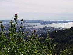
The park is managed by the East Bay Regional Park District, created from the first land the District purchased in 1936. It is largely located within unincorporated areas of Contra Costa County while parts of the park are within the cities of Oakland and Berkeley. AC Transit bus line 67 from the Berkeley BART station runs into the park on weekends. The bus line stops at the Tilden Nature Area/Little Farm, Lone Oak Road, Lake Anza/Merry-Go-Round, and the Brazilian Room/Botanic Garden before returning to Berkeley. Its steep valleys and dense stands of timber offer a rare wilderness experience so close to the city. Its high ridges and peaks give wide views over the San Francisco Bay and inland across other preserved land to Mount Diablo.
History
Prior to being a public park, the lands that are now Tilden Park were ancestral lands of Ohlone Indians. Spanish explorers and Mexican ranchos drove the Ohlone off the land as ranching became the dominant activity in Wildcat Canyon. American ranchers of the late 1800s and early 1900s included the Curran family ranch and the Sweet Briar Dairy. The eucalyptus plantations within the park were planted around 1910 by Frank C. Havens' Eucalyptus, Mahogany, & Land Company.
The first parkland was purchased by the East Bay Regional Park District from the East Bay Municipal Utility District on June 4, 1936.[2] The 2,162 acres purchased included land for Tilden Park (then called Upper Wildcat Canyon), Lake Temescal and Robert Sibley Volcanic Regional Preserve.
Upper Wildcat Canyon was officially named "Charles Lee Tilden Regional Park" on July 16, 1936.[3]
New Deal Era
At the June 4, 1936 board meeting of East Bay Regional Park District, the same meeting that authorized the land purchase, the Board appropriated $63,428 in local funds for park development. In doing so, they met their matching fund obligation in order to qualify for $1 million in federal relief funds for park development.[2]
From 1935 to 1941 a Civilian Conservation Corps (CCC) camp, "Camp Wildcat Canyon" was located in what is now the Tilden Nature Area. The CCC crews built much of the park's earlier infrastructure and features including roads, trails, bridges, picnic areas, and golf course. Works Progress Administration (WPA) crews built the Lake Anza dam and stone buildings including restrooms, the original Lake Anza beach house, and the exterior of the Brazilian Room. The aesthetic of the park today is directly derived from the original work performed by the CCC and WPA. The Brazilian Room, restroom buildings, stone monuments, and stone road ditches all remain in the park today. The stone that was used to build all the structures in the park were quarried in-park near the Big Springs trailhead on South Park Drive.
Golden Gate International Exposition
During the 1939-40 Golden Gate International Exposition, championship cricket games were held at the Meadows field in northern Tilden Park. Brazilian hardwood from the Brazilian Pavilion at the World's Fair were used extensively as the interior for Tilden Park's Brazilian Room. The East Bay Regional Park District also purchased used trash cans and benches once the World's Fair had closed.
World War II
In 1942, at the onset of World War II, 72 acres of southern Tilden Park was leased to the United States government to construct the Grizzly Peak VHF Station.[4] Beginning in 1944, the radio site served as headquarters for the San Francisco Control Group (411th Army Air Forces Control Group) that oversaw command and control for air defense radar sites across coastal Northern California. The site was also a VHF station for Hamilton Air Force Base. While the site was named after nearby Grizzly Peak on the border of Tilden Park and Oakland, the actual antennas were located atop Vollmer Peak.
In 1952, the U.S. Army opened Grizzly Peak AAA Site No. 3 at the site near Vollmer Peak as an anti-aircraft installation. Two locations had a 90mm four-gun battery. The anti-aircraft installation was decommissioned during the Cold War as a result of the opening of the Nike missile base in adjacent Wildcat Canyon Regional Park. The land was returned to the East Bay Regional Park District in 1959. The Army Camp area of the Redwood Valley Railway is the former location of the installation's barracks and mess hall. A large concrete bunker still exists and is used as a Tilden Park maintenance facility.
Camp Wildcat Canyon was used for convalescing soldiers during World War II.[5]
On September 7, 1942, the Richmond Shipyards Athletic Association put on a large scale Labor Day company picnic at Tilden Park for the thousands of workers and families of the Kaiser Richmond Shipyards. The event spanned the entire park offering a golf tournament, diving contest, band concerts, and dancing in addition to picnicking and sporting events. The event went from 8am-10pm, allowing all shipyard shifts to attend the picnic. Attendance was 10,000 people, making it the largest event in Tilden Park history.[6]
Nimitz Way paved multi-use trail was named in 1955 in honor of Admiral Chester W. Nimitz, former U.S. Pacific Fleet Commander.[7] Nimitz was known to hike in the area of Inspiration Point, spreading wild flower seeds, during the time he and his wife lived in Oakland at the Claremont Hotel and later at a residence in Berkeley.
Post-War Era
The post-war period saw the addition of pony rides, model airplane field, tennis courts, trout fishing pond, Tilden Park Merry-Go-Round in 1948, and the South Gate & Pacific Railway (precursor to the Redwood Valley Railway) in 1952.[8] With these attractions joining the already existing golf course, Botanic Garden, Brazilian Room, and Lake Anza, Tilden Park became a quintessential East Bay experience for the thousands of families that flocked to the area in the years during and after World War II.
Attractions
The park contains numerous trails, providing facilities for hiking, horseback riding and bicycling. In addition to major areas of wilderness, the park includes attractions such as a model farm, an environmental educational building, a golf course, the miniature 15 in (381 mm) gauge Redwood Valley Railway,[9] and the Regional Parks Botanic Garden. Another noteworthy attraction is the old-fashioned Tilden Park Merry-Go-Round.

One trail of note is Nimitz Way, a four-mile-long (6 km) paved trail (named after Admiral Chester W. Nimitz) that begins at Inspiration Point on the eastern edge of the park and heads north along the ridge of the hills, crossing into Wildcat Canyon Regional Park about two miles (3 km) in and ending at a peak above El Sobrante. Nimitz Way is very popular with hikers, runners and bicyclists, in part because it is paved and not very steep. From Nimitz Way there are excellent views of the San Francisco Bay to the west, EBMUD’s San Pablo & Briones Reservoirs, along with Mt. Diablo to the east. Unknown to most of the folks who travel this trail, the two-mile section that is in Wildcat Canyon Regional Park was a Nike missile base which was decommissioned in the 1970s. Today there are few signs of the missile silos and military housing that used to populate these hills.
Land and water features

Lake Anza is located in the central portion of Tilden Regional Park and is about 300 meters (980 ft) long. The lake is accessible by car and on weekends by AC Transit's 67 line, Lake Anza/Merry-Go-Round stop. The swim beach is open May–September while hiking trails and picnic areas are open year-round.
Jewel Lake, smaller than Lake Anza, is accessible only by trail.
The eastern limit of the park is approximately at the crest of the San Pablo Ridge. The western boundary nearly follows the crest of the Berkeley Hills. The East Bay Skyline National Trail runs just inside the park.
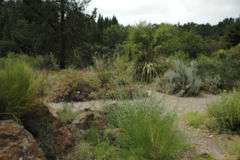
Parts of the park land had previously been cleared for agricultural use. In many places, exotic trees such as eucalyptus have been planted. There are also some relatively recently planted stands of giant sequoia. However, current conservation efforts are aimed at restoring native vegetation as much as possible, and significant parts of the park are covered in native coastal scrub. The Regional Parks Botanic Garden is located within Tilden, and features rare and endangered California flora.[10] The East Bay Regional Parks District uses grazing as a means of vegetation reduction,[11] with a herd of goats grazing each summer in Tilden.
Popular Trails
Tilden Regional Park offers a range of hiking trails most of which are dog-friendly. Dogs are not permitted in the Tilden Nature Area to the north of the park. Some of the main trails (in addition to Nimitz Way) include:
Meadows Canyon-Curran-Wildcat Canyon loop - A 1.43 miles (2.30 km) steady, but not steep, climb from Lone Oak Road which is just off Central Park Dr. At the top, Meadows Canyon connects with Curran trail which meanders downhill to Wildcat Gorge trail. To the left, it is a short walk to Lake Anza. To the right, the trail returns to take a right on Wildcat Gorge trail, it returns to the Lone Oak parking area. The total distance is a little under 3 miles (4.8 km).[12]
East Bay Skyline Ridge Trail (or Seaview Trail) - This trail provides views of San Francisco Bay to the West and Mt. Diablo to the East. It can be an out-and-back from the parking lot near the Steam Trains off of Grizzly Peak Blvd. accessed via Seaview Trail or from the opposite end off of Wildcat Canyon Road's Quarry parking area via Seaview Trail. It is approximately 2.7 miles (4.3 km) end-to-end.[13]
South Park Drive - The road that runs between Wildcat Canyon Road at the Botanic Gardens to Grizzly Peak Blvd. closes from 1 November to 31 March annually to protect the migration process for a Newt. It is available for hiking.[14]
Picnics and Camping
There are 13 reservable picnic areas and many non-reservable picnic areas within the park. They vary in amenities (potable water, grills, bathrooms) and in capacity (from 35 to 150 for reservable sites). In addition to the official picnic grounds, there are benches on most trails; many have excellent views of San Francisco and the Bay. Tilden Regional Park offers three group campsites: New Woodland with a capacity of 50 people and Gillespie Youth Camp and Wildcat View with a capacity of 75.[15] Es Anderson Equestrian Camp offers equestrian camping.
References
- ↑ "GNIS Detail - Charles Lee Tilden Regional Park". Geographic Names Information System. United States Geological Survey. 19 January 1981. Retrieved 8 April 2010.
- 1 2 Kent, Jerry. "A Brief History of the East Bay Regional Park District".
- ↑ "Parkit: Tilden Park got its name in 1936".
- ↑ "Corps of Engineers Histories: Grizzly Peak VHF Station".
- ↑ "A Modest Majesty: 70 Years of East Bay Parks".
- ↑ Treadway, Chris. "Richmond shipyards take over Tilden Regional Park on Labor Day in 1942".
- ↑ "What's the link between a WWII admiral and Berkeley?".
- ↑ "Tilden's iron horses / Miniature railroad celebrates 50 years in Berkeley".
- ↑ www.redwoodvalleyrailway.com site
- ↑
- ↑ "Grazing". www.ebparks.org. Retrieved 2016-07-29.
- ↑ http://www.ebparks.org/files/Tilden_map_north.pdf
- ↑ http://www.ebparks.org/files/Tilden_map_south.pdf
- ↑ http://www.ebparks.org/news/111708b
- ↑ http://www.ebparks.org/parks/tilden
External links
| Wikimedia Commons has media related to Tilden Regional Park. |
- Tilden Regional Park - official site at East Bay Regional Park