Tingo District
| Tingo Tinku | |
|---|---|
| District | |
|
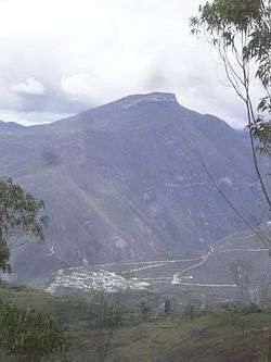
Landscape of Tingo. Kuelap can be seen from here | |
| Country |
|
| Region | Amazonas |
| Province | Luya |
| Founded | January 2, 1875 |
| Capital | Tingo |
| Government | |
| • Mayor | Victor Alan Alvarado Garcia |
| Area | |
| • Total | 102.67 km2 (39.64 sq mi) |
| Elevation | 1,950 m (6,400 ft) |
| Population (2005 census) | |
| • Total | 1,202 |
| • Density | 12/km2 (30/sq mi) |
| Time zone | PET (UTC-5) |
| UBIGEO | 010522 |
Tingo is a district of Luya Province in Peru. It borders with Colcamar to the north, Levanto and Magdalena districts of Chachapoyas Province to the east, San Juan de Lopecancha to the southeast, and Longuita to the west.
External links
| |
|---|---|
| Bagua | |
| Bongará | |
| Chachapoyas | |
| Condorcanqui | |
| Luya | |
| Rodríguez de Mendoza | |
| Utcubamba | |
Coordinates: 6°22′34″S 77°54′20″W / 6.37611°S 77.90556°W
This article is issued from Wikipedia - version of the 12/21/2015. The text is available under the Creative Commons Attribution/Share Alike but additional terms may apply for the media files.