Tomb of Ahmed Sanjar
| Tomb of Ahmad Sanjar | |
|---|---|
 | |
| Basic information | |
| Location |
|
| Affiliation | Islam |
| Year consecrated | 1157 |
| Status | in ruins |
| Architect(s) | Muhammad ibn Aziz of Sarakhs |
| Specifications | |
| Width | 17 m |
| Height (max) | 27 m |

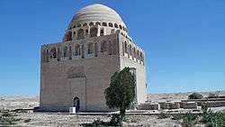
The Tomb of Ahmad Sanjar was built in Merv in 1157, following the death of Ahmad Sanjar, sultan of the Great Seljuk Empire. It is reported that his tomb was the site of pilgrimages.[1]
Tomb
The mausoleum stood 27m high and was 17m by 17m wide. The walls were 14m high and had no major decorations.[2] This was one of the grandest Seljuk tombs, with an ambitious gallery and a single dome of blue glazed bricks[3] with the drum being buttressed at four points.[4] Sanjar's mausoleum was part of a larger complex consisting of a mosque and palace,[2] while the mausoleum was centered in a vast courtyard.[5]
Mongol Invasion
In 1221, Mongols, led by Tolui, attacked Merv killing 700,000 people and burning the mausoleum.[6]
Present day
A report made in 1879-81 describes the tomb being in the center of a chahar bagh, surrounded by small tombs and graves.[7]
References
- ↑ Edmund O'Donovan, Merv and Its Surroundings, Proceedings of the Royal Geographical Society and Monthly Record of Geography, New Monthly Series, Vol. 4, No. 6, Jun., 1882:356.
- 1 2 Richard Ettinghausen, Oleg Grabar and Marilyn Jenkins, Islamic art and architecture 650-1250, (Yale University Press, 2001), 146.
- ↑ Robert Hillenbrand, Islamic Architecture: Form, Function, and Meaning, (Columbia University Press, 1994), 283, 294.
- ↑ K.A.C. Creswell, The Origin of the Persian Double Dome, The Burlington Magazine for Connoisseurs, Vol.24, No.128, Nov., 1913: 94.
- ↑ David Gye and Robert Hillenbrand, Mausolea at Merv and Dehistan, Iran. Vol. 39, (2001):53.
- ↑ John Joseph Saunders, The History of the Mongol Conquests, (University of Pennsylvania Press, 1971), 60.
- ↑ D. Fairchild Ruggles, Islamic gardens and landscapes, (University of Pennsylvania Press, 2008), 195.
See also
Coordinates: 37°39′51″N 62°09′49″E / 37.6643°N 62.1637°E