Topatopa Mountains
| Topatopa Mountains | |
|---|---|
 | |
| Highest point | |
| Peak | Hines Peak |
| Elevation | 6,716 ft (2,047 m) |
| Geography | |
| Country | United States |
| State | California |
| Region | Ventura County |
| Parent range | Transverse Ranges |
| Borders on | Sierra Pelona Mountains and Sierra Madre Mountains |
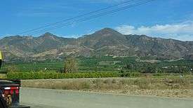
The Topatopa Mountains are a mountain range in Ventura County, California, north of Ojai, Santa Paula, and Fillmore. They are part of the Transverse Ranges of Southern California.
Geography
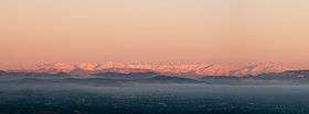
The Topatopa Mountains lie in an east-west direction east of the Sierra Madre Mountains, and west of the Sierra Pelona Mountains. To the south lies the Santa Clara River Valley into which various creeks drain starting in the mountains into the Santa Clara River. The range reaches an elevation of 6,716 feet (2,047 m) at Hines Peak, about six miles north of Thomas Aquinas College. Snow frequently falls on the high peaks during winter.
Lake Piru is the only major reservoir located within the mountains.

Natural history
The Topatopa Mountains are within the southern Los Padres National Forest. The Sespe Wilderness Area, and the Sespe Condor Sanctuary, are primarily within the Topatopa Mountains and foothills. They are part of the home range of the endangered California condor.
The habitat is of the California montane chaparral and woodlands ecoregion. Sespe Creek flows through the range, creating Sespe Gorge, with Riparian habitats of willows and woodlands.
Highest peaks
- Hines Peak - 6,716 ft (2,047 m)
- Cobblestone Mountain 6,699 ft (2,041 m)
- Topatopa Bluff - 6,367 ft (1941 m)
- Chief Peak - 5,560+ ft (1695+ m)
- Santa Paula Peak - 4,957 ft (1.511 m)
- Nordhoff Peak - 4,485 ft (1,367 m)
Adjacent Transverse Ranges
- San Emigdio Mountains - to the north
- Pine Mountain Ridge - to the north and northwest
- Sulphur Mountains (California) - northwest across the Ojai Valley
- Sierra Madre Mountains - to the west
- Santa Ynez Mountains - to the southwest
- Santa Susana Mountains - to the southeast
- Sierra Pelona Mountains - to the east
See also
| Wikimedia Commons has media related to Topatopa Mountains. |