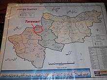
Tora Wari
| Torawari طوراوڑی | |
|---|---|
| Federally Administered Tribal Areas | |
| Country |
|
| Region | Khyber Pakhtunkhwa |
| District | Hangu District |
| Tehsil | Thall |
| Province | Federally Administered Tribal Areas |
| Continent | Asia |
| Elevation | 969 m (3,179 ft) |
| Time zone | PST (UTC+5) |
Torawari(طوراوڑی) is a village with a small population in the province of Federally Administered Tribal Areas, Pakistan which is located in the Hangu District in Khyber Pakhtunkhwa, Pakistan. It is a beautiful village covered by lot of mountains and there is a huge stone which called (lak konrah) in upper area of Torawari by which the natives of torawari climb up to (lak konrah) to see beautiful sight of torawari. The Torawari Latitude: 33°22'0.47" and Longitude: 70°43'27.47".[1]
Torawari is bordered by Khuram agency to the north, Naryab to the east, Darsamand to the west, and Doaba to the south.
Tribes
The main tribe living in Torawari is Khuidad khel. other tribes are khado khel, hassan khel, bharat khel, bharam khel and metha khel, khakhel.
by_umrfyz.jpg) lak konrah of torawari
lak konrah of torawari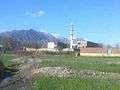 sight of torawari
References
Coordinates: 33°22′0″N 70°43′27″E / 33.36667°N 70.72417°E