Torsburgen
| Torsburgen | |
|---|---|
| Tors borg or þors borg | |
|
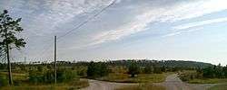
The Torgburgen plateau hill from a distance | |
| Type | Hillfort |
| Location | Kräklingbo, Gotland, Sweden |
| Nearest city | Ljugarn |
| Coordinates | 57°24′45″N 18°43′15″E / 57.41250°N 18.72083°ECoordinates: 57°24′45″N 18°43′15″E / 57.41250°N 18.72083°E |
| Area | 1.2 km2 (0.46 sq mi) |
| Elevation | 71 m (233 ft) |
| Built | 1st-4th century |
| Governing body | Gotland County |
| Nature reserve | Natura 2000[1] |
| RAÄ-number | Kräklingbo 53:1[2] |
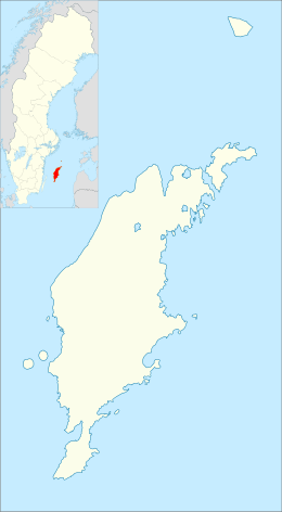 Torsburgen location on Gotland | |
Torsburgen, Tors borg or þors borg ("Thor's fort/castle") are the remains of an ancient hillfort in Kräklingbo on the Swedish island of Gotland in the Baltic Sea. The fort is approximately 1.2 km2 (0.46 sq mi), was constructed in the 1st-4th century and in use until the 12th century. Situated on a plateau hill it is protected by high cliffs and wall sections, almost 2 km (1.2 mi) long in total. The fort is featured in the Gutasaga. The plateau is also a nature reserve.
Geography
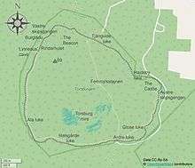
Torsburgen is situated on, and encompasses the whole of, an eponymous plateau hill in the central east part of Gotland.[3] With 10–25 m (33–82 ft) steep cliffs in the west, north and east, it rises above the surrounding flat landscape.[4] About 10,300–10,800 years ago it was a low island in the Baltic Ice Lake. The motions of that lake deposited gravel embankments in the southwest part of the plateau. Inside the embankments, now walls, has formed a small mire called Torsburgsmyr.[5]
There are several caves in the cliffs along the northwest side, the deepest is the Burglädu (Gutnish for "Castle barn") at 16 m (52 ft). Another is Linneaus' Cave, named after Carl Linnaeus who visited the hillfort in 1741.[5] There is also the Rindarhulet. Rindi is Gutnish for ivy, a common plant on Gotland, and hulet means "the hole".[2][6]
The hill and the surrounding area used to be covered with dense coniferous forest. Most of the forest was destroyed during the large Kräklingbo fire in the dry summer of 1992. Nevertheless, the area has given life to a wide variety of fire-dependent fungus, plants and insects, some of which are endangered species.[1] Torsburgen has been ravaged by fires before. On his visit to the hill, Linneaus noted that the plateau was almost void of trees. He was probably referring to the great fire of 1655, which ravaged the Alskog, Ala, Ardre and Kräklingbo sockens.[5]
History
The hillfort was originally constructed at the beginning of the 1st century AD. Reinforced during the 4th century, it was in use until c. 1100 AD.[7] Another source, based on an archaeological survey done in the 1970s, dates the two stages of constructing the fort to 300 AD and 900 AD.[4][8] A timber-laced stone rampart encircled an area of 12 ha (30 acres). Scholars estimate that nearly 1000 soldiers would have been needed to defend it [7] and it could have been providing refuge to the entire population of Gotland that is calculated to be between 6,000 and 10,000 in the early medieval period.
The fortification is approximately 1,300 m × 730 m–1,200 m (4,270 ft × 2,400 ft–3,940 ft) (E–W).[2] The enclosed area on Torsburgen is about twice the size of the land enclose by the Visby city wall.[3] The fort follows the natural edge of the plateau. The steep cliffs provide a natural protection for the hillfort in the west, north and east part of the plateau, with reinforcements and constructed walls in some places. In the northeast is a 40 m (130 ft) long wall made of large limestone blocks. The area is known as "The Castle" (Swedish: Slottet). In the southwest and south, the fort is protected by a 1.5 km (0.93 mi) long wall. The most western part of the wall is built of limestone slabs, while the southwest and south parts are made of limestone rubble and dirt.[2] The wall is 4–7 m (13–23 ft) high and up to 24 m (79 ft) wide.[4] On top of the wall was a palisade of logs.[3] The limestone used for building the wall was quarried on site at a small quarry in the north part of the plateau.[2] It has been estimated that the wall would take 3,000 men a year to build. Very little archaeological work has been done on Torsburgen, most of it is unexamined. Only four small metal objects have been retrieved during a minor excavation in connection to a restoration of the stone work at Ardre luke in 1983.[3][2][9]

There are several openings in the walls, in Gutnish called luke (Swedish: lucka), each with its own name:[2]
- Tjängvide like
- Hajdeby luke
- Glose luke
- Ardre luke
- Halsgårde luke
- Ala luke
It has been suggested that Torsburgen was part of a defense system for lighting fire beacons on the many hill forts and plateau hills on the island, to warn the population about approaching enemy ships.[3]
Torsburgen is the third largest hillfort in Scandinavia.[5] The largest is Halleberg in Västergötland, Sweden at about 20 km2 (7.7 sq mi),[10] and the second largest is Lollands Österborg on east Lolland, Denmark at about 5 km2 (1.9 sq mi).[11] The fourth largest in Scandinavia and second largest on Gotland is the hillfort on Grogarnsberget.[12]
Guta Saga
In the exodus story of the Guta Saga, the mythological history of Gotland, a third of Gotland's residents once temporarily settled themselves in Torsburgen after they were ordered by the local government to move due to overpopulation concerns. These residents were eventually forced to leave Gotland altogether; they subsequently settled in Fårö and Hiiumaa before finally moving through Russia to Greece, where they became the descendants of the Goths.[13]
Nature reserve
In 1994, Torsburgen was designated as a nature reserve. The reserve comprises the whole plateau and the area immediately surrounding its base, which translates to 158 ha (390 acres). The flora includes a number of plants that are rare in Sweden, such as hard shield-ferns, scorpion senna, Orobanche alba and the Pulsatilla vulgaris gotlandica; all of which survived the fire in 1992.[5] On 30 August 2005, the nature reserve became a Natura 2000 protected area. A number of endangered species of plants and insects on the IUCN Red List have been found within the area.[1]
Gallery
 Cliffs in the north part beneath The Castle
 The walls at Ardre luke
 Part of the stone wall
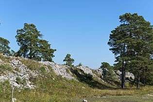 Part of the east wall
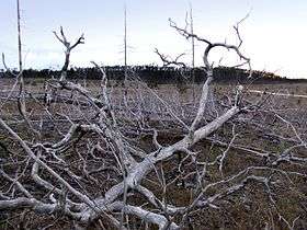 Torburgen seen from the land below the hill some years after the great fire
References
- 1 2 3 "Torsburgen SE0340040" (PDF). www.lansstyrelsen.se. Gotland County Administrative Board. Retrieved 14 June 2016.
- 1 2 3 4 5 6 7 "RAÄ-nummer Kräklingbo 53:1". www.raa.se. Swedish National Heritage Board. Retrieved 14 June 2016.
- 1 2 3 4 5 Enderborg, Bernt. "Torsburgen - þors borg, Tors borg". www.goteinfo.com. Guteinfo. Retrieved 14 June 2016.
- 1 2 3 Henriksson, Greta (7 September 2014). "Kräklingbo: Torsburgen". www.gotland.se. Gotland Municipality. Retrieved 15 June 2016.
- 1 2 3 4 5 "Torsburgen". www.lansstyrelsen.se. Gotland County Administrative Board. Retrieved 13 June 2016.
- ↑ "Ortnamnsregistret" [Location Name Register]. www2.sofi.se. Institutet för språk och folkminnen. Retrieved 14 June 2016.
- 1 2 Helle, Knut (2003). The Cambridge History of Scandinavia. New York: Cambridge University Press. p. 75. ISBN 978-0-521-47299-9. OCLC 53982606.
- ↑ Engströpm, Johan (1984). Torsburgen : tolkning av en gotländsk fornborg [Torsburgen : interpretation of a Gotlandic hillfort]. Archaeological studies / Uppsala University, Institute of North European Archaeology, 0348-7628 ; 6. Uppsala: Inst. för arkeologi, Univ. (distr.). ISBN 91-506-0571-2. LIBRIS 7402526.
- ↑ The archaeological finds marked on this map from the Swedish National Heritage Board are all above ground, and the Swedish History Museum database only hold four objects from Torsburgen.
- ↑ "Fornborgen" [The Hillfort]. www.tunhemsbygden.se. Västra Tunhems Hembygdsförening. Retrieved 13 June 2016.
- ↑ Thorsen, Sven (2001). "En to-tre folkeborge - én på Falster, og to på Lolland". 89: 5–16.
- ↑ "Grogarnsberget Nature Reserve". www.lansstyrelsen.se (in Swedish). Gotland County Administrative Board. Retrieved 31 January 2012.
- ↑ Kaplan, Merrill; Tangherlini, Timothy (2012). News from Other Worlds. Berkeley and Los Angeles: North Pinehurst Press. p. 98.
| Wikimedia Commons has media related to Torsburgen. |
