Wartau
| Wartau | ||
|---|---|---|
|
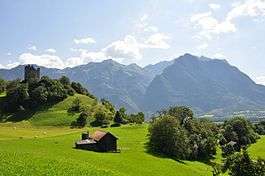
View of the ruined Wartau castle, looking south-east across the Rhine Valley towards Mittagspitz | ||
| ||
 Wartau | ||
|
Location of Wartau 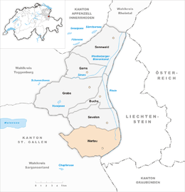 | ||
| Coordinates: 47°5′N 9°29′E / 47.083°N 9.483°ECoordinates: 47°5′N 9°29′E / 47.083°N 9.483°E | ||
| Country | Switzerland | |
| Canton | St. Gallen | |
| District | Werdenberg | |
| Government | ||
| • Mayor | Beat Tinner | |
| Area[1] | ||
| • Total | 41.73 km2 (16.11 sq mi) | |
| Elevation | 468 m (1,535 ft) | |
| Population (Dec 2015[2]) | ||
| • Total | 5,231 | |
| • Density | 130/km2 (320/sq mi) | |
| Postal code | 9476-9479 | |
| SFOS number | 3276 | |
| Surrounded by | Balzers (LI), Flums, Mels, Sargans, Sevelen, Triesen (LI), Walenstadt | |
| Website |
www SFSO statistics | |

Wartau is a municipality in the Werdenberg constituency of the Swiss canton of St. Gallen. The municipality consists of a number of villages on the eastern flank of the Alvier group, along the left shore of the Alpine Rhine.
Geography
Wartau municipality consists of the villages of Azmoos (482 m), Trübbach (478 m), Weite (469 m) along the Rhine, Oberschan (668 m), Malans (617 m), Gretschins (600 m) and Fontnas (542 m) in the foothills of the Alvier chain, the hamlets of Plattis (464 m) and Murris (470 m), and Matug (731 m) and environs, historically a Walser Streusiedlung.
Wartau municipality has an area, as of 2006, of 41.8 km2 (16.1 sq mi). Of this area, 47.1% is used for agricultural purposes, while 37.1% is forested. Of the rest of the land, 6.4% is settled (buildings or roads) and the remainder (9.5%) is non-productive (rivers or lakes).[3]
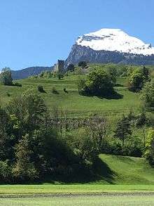
The highest point of the municipality is Alvier peak, at 2,343 m, the lowest point is the Rhine Valley at 461 m.
Demographics
Wartau has a population (as of 31 December 2015) of 5,231.[4] As of 2007, about 23.3% of the population was made up of foreign nationals. Of the foreign population, (as of 2000), 84 are from Germany, 176 are from Italy, 424 are from ex-Yugoslavia, 53 are from Austria, 25 are from Turkey, and 155 are from another country.[5] Over the last 10 years the population has grown at a rate of 6.7%. Most of the population (as of 2000) speaks German (88.5%), with Albanian being second most common ( 3.2%) and Italian being third ( 2.9%).[3] Of the Swiss national languages (as of 2000), 4,161 speak German, 9 people speak French, 135 people speak Italian, and 11 people speak Romansh.[6]
The age distribution, as of 2000, in Wartau is; 637 children or 13.5% of the population are between 0 and 9 years old and 666 teenagers or 14.2% are between 10 and 19. Of the adult population, 565 people or 12.0% of the population are between 20 and 29 years old. 762 people or 16.2% are between 30 and 39, 731 people or 15.5% are between 40 and 49, and 561 people or 11.9% are between 50 and 59. The senior population distribution is 358 people or 7.6% of the population are between 60 and 69 years old, 283 people or 6.0% are between 70 and 79, there are 119 people or 2.5% who are between 80 and 89, and there are 22 people or 0.5% who are between 90 and 99.[6]
In 2000 there were 530 persons (or 11.3% of the population) who were living alone in a private dwelling. There were 976 (or 20.7%) persons who were part of a couple (married or otherwise committed) without children, and 2,775 (or 59.0%) who were part of a couple with children. There were 269 (or 5.7%) people who lived in single parent home, while there are 46 persons who were adult children living with one or both parents, 26 persons who lived in a household made up of relatives, 14 who lived household made up of unrelated persons, and 68 who are either institutionalized or live in another type of collective housing.[6]
In the 2007 federal election the most popular party was the SVP which received 42.3% of the vote. The next three most popular parties were the FDP (23.2%), the SP (15.7%) and the CVP (7.3%).[3]
In Wartau about 70.2% of the population (between age 25-64) have completed either non-mandatory upper secondary education or additional higher education (either university or a Fachhochschule).[3] Out of the total population in Wartau, as of 2000, the highest education level completed by 991 people (21.1% of the population) was Primary, while 1,759 (37.4%) have completed their secondary education, 440 (9.4%) have attended a Tertiary school, and 232 (4.9%) are not in school. The remainder did not answer this question.[6]
History
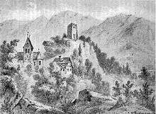
There are a number of Mesolithic, Neolithic and Bronze Age traces, as well traces of an early medieval estate. The name Wartau is taken from that of Wartau castle, built in 1225 (overlooking Gretschins, at 47°05′55″N 9°29′26″E / 47.0985°N 9.4905°E). The center of the medieval manor was at Gretschins, with a church first mentioned in 1273.
The lordship of Wartau passed to the counts of Werdenberg-Heiligenberg in 1399, and further to Lucerne in 1485 and to Glarus in 1517. In the 14th century, the higher parts of the territory of the modern municipality (Matug, Walserberg, Palfris) were settled by Walser. High justice lay with the county of Sargans from 1483 until 1798. There was a Rhine ferry between Trübbach and Balzers in the medieval period. The Swiss Confederacy constructed a road along the Rhine to Sargans in 1491/2.
The church at Gretschins was dedicated to Saint Martin in 1494, but the parish adopted the Swiss Reformation at an early time, in the 1520s. Attempts to re-introduced the Catholic mass in 1694/4 resulted in the "Wartau conflict" (Wartauerhandel), which almost triggered a larger religious war in the Swiss Confederacy. A second church was built in Azmoos in 1736.
The municipal coat of arms is attested on a stained glass panel dated 1632. It shows a grapevine below a gold star in a red field (Gules a Vine Stump Vert leaved issuant from Coupeaux of the same and in chief a Mullet Or). An unrelated municipal coat of arms, showing the castle ruins, was designed in 1939. This was replaced in favour of the historical coat of arms in the 1970s.[7]
In 1802, a short-lived "Republic of Wartau" was proclaimed, before the modern municipality was formed as part of the Swiss canton of St. Gallen in 1803. The Walser population which now found itself on the territory of the municipality was naturalized only in 1827, under pressure from the cantonal authorities. Railway stations at Trübbach and Weite were built in 1858. The Rhine ferry was replaced by a bridge in 1872. The A13 motorway dates to 1967.[8]
The prehistoric settlement and sacrifice site at Gretschins-Herrenfeld and Ochsenberg, as well as the nearby medieval castle ruins and the Walser Rathaus (council house) auf Palfries are listed as Swiss heritage sites of national significance.[9]
The villages of Azmoos and Oberschan as well as the hamlets of Fontnas and Gretschins are designated as part of the Inventory of Swiss Heritage Sites.[10]
Economy
As of 2007, Wartau had an unemployment rate of 1.46%. As of 2005, there were 174 people employed in the primary economic sector and about 57 businesses involved in this sector. 933 people are employed in the secondary sector and there are 45 businesses in this sector. 720 people are employed in the tertiary sector, with 159 businesses in this sector.[3]
As of October 2009 the average unemployment rate was 2.7%.[11] There were 253 businesses in the municipality of which 49 were involved in the secondary sector of the economy while 151 were involved in the third.[12]
As of 2000 there were 1,017 residents who worked in the municipality, while 1,407 residents worked outside Wartau and 926 people commuted into the municipality for work.[13]
Religion
The parish of Gretschins was probably established in the early 13th century (first mention 1273). The church of Gretschins was rebuilt in 1494 and dedicated to Saint Martin. The Swiss Reformation was adopted still in the 1520s, and the population resisted attempts made by Glarus in the 17th century of re-introducing Roman Catholicism. Azmoos-Trübbach was established as a separate parish in 1743.
A Catholic church was built in Azmoos 1892, and Catholic population gradually increased, reaching parity by the later 20th century. As of the 2000 census, 42% of population were Catholic and 38% belonged to the Swiss Reformed Church. Wartau has received a significant immigrant population since the later 20th century, reflected by 7.8% (367 individuals) identifying as Muslim in the 2000 census. 5.5% (261 individuals) identified as non-religious (atheist or agnostic).[6]
References
- ↑ Arealstatistik Standard - Gemeindedaten nach 4 Hauptbereichen
- ↑ Swiss Federal Statistical Office - STAT-TAB, online database – Ständige und nichtständige Wohnbevölkerung nach institutionellen Gliederungen, Geburtsort und Staatsangehörigkeit (German) accessed 30 August 2016
- 1 2 3 4 5 Swiss Federal Statistical Office accessed 19-January-2010
- ↑ Swiss Federal Statistical Office - STAT-TAB, online database – Ständige und nichtständige Wohnbevölkerung nach institutionellen Gliederungen, Geburtsort und Staatsangehörigkeit (German) accessed 30 August 2016
- ↑ Der Kanton St. Gallen und seine Menschen in Zahlen - Ausgabe 2009 (German) accessed 30 December 2009
- 1 2 3 4 5 Canton St. Gallen Statistics-Hauptergebnisse der Volkszählung 2000: Regionen- und Gemeindevergleich-Personen (German) accessed 30 December 2009
- ↑ Die seltsame Geschichte des Wartauer Wappens (wartau.ch)
- ↑ Wartau in German, French and Italian in the online Historical Dictionary of Switzerland, 2013.
- ↑ Swiss inventory of cultural property of national and regional significance 21.11.2008 version, (German) accessed 19-Jan-2010
- ↑ ISOS site accessed 19-Jan-2010
- ↑ St Gallen Canton statistics-Unemployment (German) accessed 30 December 2009
- ↑ St Gallen Canton statistics-Businesses (German) accessed 31 December 2009
- ↑ St Gallen Canton statistics-Commuters (German) accessed 31 December 2009
External links
| Wikimedia Commons has media related to Wartau. |
- Official website (German)