Trainmeusel
| Trainmeusel | |
|---|---|
| Village of Wiesenttal | |
|
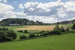
View of the village | |
 Trainmeusel | |
| Coordinates: 49°47′43″N 11°14′50″E / 49.79539°N 11.24714°ECoordinates: 49°47′43″N 11°14′50″E / 49.79539°N 11.24714°E | |
| Country | Germany |
| State | Bavaria |
| Municipality | Wiesenttal |
| Elevation | 445 m (1,460 ft) |
| Population (1987) | |
| • Total | 90 |
| Time zone | CET/CEST (UTC+1/+2) |
| Dialling codes | 09196 |
Trainmeusel is a village in the Upper Franconian market municipality of Wiesenttal in the district of Forchheim in the German state of Bavaria.
Location
The village lies within the Franconian Switzerland-Veldenstein Forest Nature Park, about 1.3 kilometres southwest of Muggendorf on a Jurassic plateau of the Franconian Jura. The village may be reached by car from Muggendorf on the Kreisstrasse FO35. Its neighbouring villages in clockwise order are Muggendorf, Wohlmannsgesees, and Birkenreuth.[1]
History
Trainmeusel was probably founded in the 9th century. The village was first mentioned in 1137. Its name is derived from the Slavic Dragomysl and means "Dragomysl's place".
Today
The village is rural in character, has no shops and one inn.[2]
Near Trainmeusel is the Trainmeusel Spring, a spring formed between two layers of rock (Schichtquelle) which is protected as a natural monument.
References
- ↑ Lage Trainmeusel im BayernAtlas (Abgerufen am 17. August 2016)
- ↑ Infotafel am Trainmeuseler Brunnen, Bild in Commons
Weblinks
| Wikimedia Commons has media related to Trainmeusel. |