Transport geography
Transport geography, also transportation geography, is a branch of geography that particularly investigates the movement of and connections between people, goods or information on the Earth's surface.
Aims and scope
Transportation geography detects, describes and explains the Earth's surface's transportation spaces regarding location, substance, form, function and genesis, and asks for the effects of transportation on other spatial processes, land use and land cover patterns. Moreover, it contributes to transport, urban and regional planning.
Transportation, or more basically, movement, is fundamental to the economic activity of exchange. Therefore, transport geography and economic geography are largely interrelated. At the most basic level, humans move and thus interact with each other by walking, but transportation geography typically studies more complex and regional or global systems of transportation that include multiple interconnected modes like public transit, personal cars, bicycles, freight railroads, the Internet, airplanes and more. Such systems are increasingly urban in character. Thus, transport and urban geography are closely intertwined. Cities are very much shaped, indeed created, by the types of exchange and interaction facilitated by movement.[1] Increasingly since the 19th century, transportation has been seen as a way cities, countries or firms compete with each other in a variety of spaces and contexts.[2]
Transportation modes
In terms of transport modes, the primary forms are air, rail, road, and water. Each one has its own cost associated with speed of movement, as a result of friction and place of origin and destination. For moving large amounts of goods, ships are generally used. Maritime shipping is able to carry more at a cheaper price around the world. For moving people who prefer to minimize travel time, and maximize comfort and convenience, air and road are the most common modes in usage. A railroad is often used to transport goods in areas away from water.
" Transportation modes are an essential component of transport systems since they are the means by which mobility is supported. Geographers consider a wide range of modes that may be grouped into three broad categories based on the medium they exploit: land, water and air. Each mode has its own requirements and features, and is adapted to serve the specific demands of freight and passenger traffic. This gives rise to marked differences in the ways the modes are deployed and used in different parts of the world. Recently, there is a trend towards integrating the modes through intermodality and linking the modes ever more closely into production and distribution activities. At the same time; however, passenger and freight activity is becoming increasingly separated across most modes." [3]
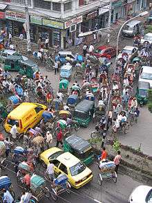
Road transportation
Road transportation networks are the type of transportation that is connected with movements on constructed roads; carrying people and goods from one place to another by means of lorries, cars, etc.
Maritime transportation
Water transportation is the slowest form of transportation in the movement of goods and people. Strategic chokepoints around the world have continued to play significant roles in maritime industry.
Challenges for transportation
Traffic and transportation on existing streets, highways, and rail facilities no longer match demands created by a recent population growth, and new location patterns of economic activity. Besides an increase in population, another problem is vehicles overloading the network of highways and arterial streets. See Traffic congestion, Transportation network, and Population densities
See also
References
- ↑ Braudel, F. 1949 / 1995 The Mediterranean and the Mediterranean World in the Age of Phillip II. Berkeley: University of California Press
- ↑ Graham, S., Marvin, S. 2001. Splintering Urbanism: Networked Infrastructures, Technological Mobilities and the Urban Condition: Networked Infrastructures, Technological Mobilites and the Urban Condition. London: Routledge.
- ↑ Dr. Jean-Paul Rodrigue, Dept. of Economics & Geography, Hofstra University
Sub-fields of and approaches to human geography | ||
|---|---|---|
| Sub-fields |  | |
| Approaches | ||