Traunstein
| Traunstein | ||
|---|---|---|
| ||
 Traunstein | ||
Location of Traunstein within Traunstein district 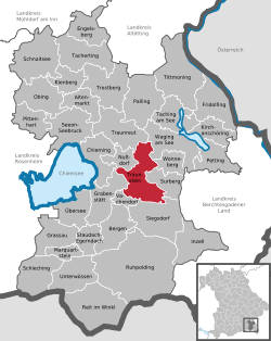 | ||
| Coordinates: 47°52′N 12°38′E / 47.867°N 12.633°ECoordinates: 47°52′N 12°38′E / 47.867°N 12.633°E | ||
| Country | Germany | |
| State | Bavaria | |
| Admin. region | Oberbayern | |
| District | Traunstein | |
| Government | ||
| • Mayor | Christian Kegel ("SPD") | |
| Area | ||
| • Total | 48.53 km2 (18.74 sq mi) | |
| Population (2015-12-31)[1] | ||
| • Total | 19,642 | |
| • Density | 400/km2 (1,000/sq mi) | |
| Time zone | CET/CEST (UTC+1/+2) | |
| Postal codes | 83278 | |
| Dialling codes | 0861 | |
| Vehicle registration | TS | |
| Website | www.traunstein.de | |


Traunstein is a town in the south-eastern part of Bavaria, Germany, and is the administrative center of a much larger district of the same name. The town serves as a local government, retail, health services, transportation and educational center for the wider district.
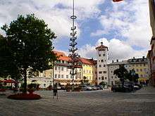
The historic market square, Bavarian hospitality, local breweries, outdoor sports facilities, Easter Monday horse parade and connections with Pope Emeritus Benedict XVI, contribute to the town's profile as a tourist destination.
Geography
The town is situated at the heart of a region called Chiemgau, approximately 11 km east of Lake Chiemsee between Munich and Salzburg, 15 km north of the Alps, and 30 km west of Salzburg.
History
Early history
Although in 790, the church records already list possessions "ad Trun" and some medieval defence constructions are known to have existed in the surroundings since the 10th century, Trauwenstein itself was first mentioned in a manuscript of the Baumburg monastery in the year 1245. The name means "castle on the Traun," and the domicile of the Lord of "de Truna," surrounded by a little settlement, was likely located there.
The Wittelsbachers (a German/Bavarian dynastic and European royal family) were the first to expand and fortify the settlement. In this way they controlled the passage of the important commercial salt route over the Traun, from Bad Reichenhall to Munich at the border of the "Erzstift Salzburg" (the archbishopric of Salzburg). In the year 1120 the lords of "Truna" settled in the current-day urban area because of its favourable strategic position. They built the castle at the border of the city plateau, which is surrounded by the River Traun as well as its close proximity to the main route of commerce.
Traunstein has been part of the state of Bavaria since 1275. It was previously a territory of Salzburg. At the beginning of the 14th century, Traunstein was granted the status of a town. By 1493 the town roads were already cobbled. The Church of St. Oswald was rebuilt in 1501. In 1526 the Lindlbrunnen (Lindl Fountain) was constructed as a completion of the town's water supply.
In the 17th century, salt production, facilitated by the construction of a wooden, brine pipeline from Bad Reichenhall brought new industry and significant wealth to the town. The pipeline was constructed between 1616 and 1619 by the master builder of the court, Hans Reiffenstuel.
Traunstein was spared much of the damage experienced by nearby towns during the Thirty Years' War (1618–1648). [reason/s and citation/s needed]
On the 25th and 26 July 1704, Austrian troops occupied the town in the course of the Spanish war of succession. A disastrous fire altered the medieval townscape. Despite the occupation by Austrian troops, it was possible for Traunstein to be reconstructed. The saltworks, finished in 1786/87, assured the survival of the salt production in Traunstein.
Town fires
In its history, Traunstein was struck at least twice by significant town fires: In 1704, when Hungarian "Panduren" set the town on fire in the course of the Spanish War of Succession, and in 1851. However, the "first town fire", which is still familiar to all "real" citizens of Traunstein and is still taught at school today, hasn't been confirmed yet. Only archaeological excavations can show whether Traunstein had really suffered a fire disaster before 1400. Anyway, written documents provide no information about it. They merely report about a fire, which broke out later, in 1851. However, only 10 houses fell victim to the fire and in no case the whole town. Thereupon, in 1587, a fire arrangement was enacted for the first time in the town history.
During the night of April 25 to April 26, 1851, a disastrous fire destroyed again almost the whole town. The reason for it has never been discovered. The great fires spread to almost 100 houses including the Town Hall, the County Court, the Main Salt Office, the Pension Office, the Church and several gates and towers except the Upper Tower. Just like in 1704, Traunstein would again be rebuilt in a few years. It was presumed the fire was an act of revenge by the angry Haslachers. There were feelings of rage because the parochial seat was taken away from Haslach and was given to Traunstein. Later rumours came up that the carelessness of a resident had caused the fire. However, there was no evidence to support this idea and therefore the person could not be sentenced.
After the town fire 700 citizens were homeless but help immediately reached Traunstein. King Maximilian II visited Traunstein on the 27th of April, contributed consolations and gave several thousands of guilders from his cabinet cash. In return for the quick payment of the fire assurance the inhabitants could soon begin to rebuild their town from ground up. Besides, the medieval plan of the town square was preserved to a great extent, merely the facades received a new face in the style of the current time.
1900 to present
Salt production in Traunstein was finally shut down in 1912. In 1914, the former independent community "Au" became part of Traunstein.
During the First World War what had previously been the site of the salt production facilities became a camp for over 1000 civilian prisoners and prisoners of war. After the war, the World Economic Crisis of 1923 resulted in the hyperinflation and as in other towns the use of token money, denominated in billions, was widespread.

With the seizure of power of the National Socialists in 1933 began an active period of persecution for political dissidents and Jewish fellow citizens in Germany. By November 1938 all Jewish residents of the town had been forcibly removed. Open political resistance during the war years was limited; the town priest, Josef Stelze, was placed briefly in custody, Rupert Berger, Bavarian People's Party representative and the first post-war elected Mayor of Traunstein, was for a period incarcerated in the Dachau concentration camp. In 1939 Traunstein had an estimated population of 11,500. By the end of the war 523 of this number was registered as killed as a direct result of the conflict, a further 73 registered as missing.[2]
During the later stages of the Second World War Traunstein was four times the target of American aerial bombardment: on November 11, 1944, on January 21, 1945, on April 18, 1945, and finally on April 25, 1945. In April 1945 the heavy air raids destroyed much of the Traunstein station area an event in which over 100 people died. Little time later, on May 2, 1945, a train with Jewish concentration camp detainees passed through Traunstein. The following day 61 of the detainees were shot in Surberg, where a memorial commemorates them. The town surrendered without struggle on May 3, 1945.
During World War II, a subcamp of Dachau concentration camp was located here.[3] Whereas Traunstein was a district free city from 1948–1972, it became capital of the district denominated by the same name in 1972.
Areas of Traunstein close to the River Traun have been subject to flooding on numerous occasions, most notably in 1899 [4] and again in 2013.[5]
Transportation
- Road: The Bundesautobahn 8 linking Munich and Salzburg, Austria crosses to the south of the town.
- Rail: The rail link between Munich and Salzberg was established in 1860. Traunstein station remains a major rail intersection with long-distance intercity and local trains connecting to the Ruhpolding branch line making frequent stops.
- Aircraft: International airports are located in Munich (120 km,74 mi) and Salzburg (35 km,21 mi). A regional aerodrome 21 km north consists of Traunstein in Schoenberg.
Notable former residents
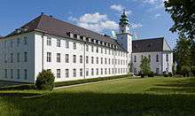
- Pope Emeritus Benedict XVI. Born Joseph Ratzinger, spent much of his early childhood and teenage years living in Traunstein and with his brother Georg attended the St. Michael Seminary in the town.
- Emeran Mayer, MD/PhD Renown Scientist, Author, Lecturer was born in Traunstein in 1950
Twinned cities
-
 Gap, France
 -
 Pinerolo, Italy
 -
 Wesseling, NRW, Germany
 -
 Haywards Heath, West Sussex, England[6]
 -
 Kinross, Scotland
References
- ↑ "Fortschreibung des Bevölkerungsstandes". Bayerisches Landesamt für Statistik und Datenverarbeitung (in German). June 2016.
- ↑ "Traunstein Town History". Town History Timeline. Traunstein Local Government. Retrieved 28 May 2014.
- ↑ http://www.glosk.com/GM/Linde/17283/pages/List_of_subcamps_of_Dachau/84737_en.htm
- ↑ "Traunstein Town History". Town History Timeline. Traunstein Local Government. Retrieved 28 May 2014.
- ↑ http://www.traunstein.de/Aktuelles/Presseberichte.aspx?rssid=BD2823F7-4FE9-4BF7-AB27-37A56F6F9077
- ↑ http://www.localauthoritypublishing.co.uk/councils/h_heath/twinning.html