Trinidad Head, California
| Trinidad Head | |
|---|---|
|
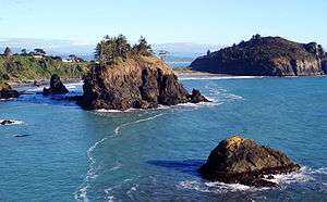
Only a narrow spit connects Trinidad Head (upper right) to the mainland | |
| Location | Trinidad Harbor, near Trinidad, California |
| Coordinates | 41°03′16″N 124°09′03″W / 41.054308°N 124.150914°WCoordinates: 41°03′16″N 124°09′03″W / 41.054308°N 124.150914°W |
| Reference no. | 146 |
 Location of Trinidad Head in California | |
Trinidad Head (Yurok: Chuerewa' [1]) is a rocky promontory surrounded by sea stacks sheltering Trinidad Harbor, adjacent to the town of Trinidad in Humboldt County, California, USA, designated as California Historical Landmark #146.[2]
History
On 9 June 1775, two Spanish Naval explorers, Bruno de Heceta and Juan Francisco de la Bodega y Quadra anchored in Trinidad Bay. Two days later, on Trinity Sunday, 11 June 1775,[3] Trinidad Head was claimed for Spain in the name of Charles III by Heceta, his men and two Franciscan fathers who erected a cross on the summit. When Sebastian Rodriguez Cermeno, Captain of the Portuguese ship "San Augustin," discovered and entered the Trinidad Bay in November of 1595, he did not anchor for fear of hitting submerged rocks.[4] Over the next 75 years, Spanish, Russian and British ships landed at Trinidad Head for sea otters, fresh water and refuge from storms.[5]
The harbor and Trinidad Head were mapped as part of A.D. Bache's United States Coast Survey under the direction of Lieutenant Commander William P. McArthur.[6]
Geology
Trinidad Head is composed of metamorphosed gabbro embedded in the surrounding Franciscan melange, topped with Pleistocene sands and gravels.[7]
Observatories
- The Trinidad Head Lighthouse was built 1871 and remains in operation.
- Trinidad Head Observatory of the National Oceanic and Atmospheric Administration began operation in 2002, monitoring regional and global meteorology.[8]
- NASA's Advanced Global Atmospheric Gases Experiment began on Trinidad Head in 1995 and was updated to a system which can measure more than 40 trace gases in May 2005.[9]
References
- ↑ "Yurok Dictionary: Chuerewa'". Retrieved 2012-07-07.
- ↑ "Trinidad Head". Office of Historic Preservation, California State Parks. Retrieved 2012-10-07.
- ↑ Tovell, Freeman M. (2008). At the Far Reaches of Empire: The Life of Juan Francisco De La Bodega Y Quadra. University of British Columbia Press. pp. 22–23. ISBN 978-0-7748-1367-9.
- ↑ Turner, Dennis & Gloria (2010). Place Names of Humboldt County, California (2nd ed.). Humboldt Room, HSU: Dennis W. & Gloria H. Turner. p. 237. ISBN 978-0-9629617-2-4.
- ↑ Trinidad Gateway Brochure (PDF). California Coastal National Monument - Trinidad Gateway. Arcata Field Office: Bureau of Land Management. p. 5. Retrieved 22 April 2011.
- ↑ Bache, Alexander Dallas (1851). Reconnaissance of Trinidad Bay California-Chart with soundings, coastline & settlements; includes View of Trinidad Head and City. Washington, DC: U.S. Coast and Geodetic Survey. p. 1.
- ↑ Trinidad Beach Field Trip. Geology 109, Lab 6. Arcata, California: Humboldt State University. 2009.
- ↑ "Trinidad Head Observatory". Earth System Research Laboratory, Global Monitoring Division. National Oceanic and Atmospheric Administration. Retrieved 22 April 2011.
- ↑ "Trinidad Station". Advanced Global Atmospheric Gases Experiment. NASA. Retrieved 22 April 2011.
| Wikimedia Commons has media related to Trinidad,_California. |
