Truckee Meadows

The Truckee Meadows area is the second largest population center in Nevada.[1] Based on Topographical mapping data from the USGS, Truckee Meadows is located in Washoe County and starts at the furthest southern runway of Reno Tahoe International Airport (GPS Coordinates 39.468836,-119.770912), The Truckee Meadows encompasses Rattle Snake Mountain at Huffaker Park, following the span of Steamboat Creek to the southern east end of Washoe and Story Countyending at the base of the Virginia Highlands. (GPS Coordinates 39.392730,-119.714006)[2][3] The Truckee Meadows is a north-south trending basin covering approximately 94 square miles in western Nevada. It is bounded on the west by the Carson Range, on the east by the Virginia Range, on the south by the Steamboat hills, and by Peavine Mountain to the north.[4]
General Features of The Area
The Truckee Meadows area is one of a series of valleys in northwestern Nevada that is bordered on the west by the Sierra Nevada Range and on the east by the Virginia Range and to the south, the Pine Nut Range. The "Truckee Meadows area" defines the topographic basin bordered on the west by the Carson Range, which is a spur of the Sierra Nevada Range, on the east by the Virginia Range, on the north by units of these two ranges, and on the south by Pleasant Valley. Steamboat Creek is the main tributary supplying the Truckee River through the Truckee Meadows. Steamboat Creek, flows north-ward into Steamboat Valley. Steamboat Valley is considered part of the Truckee Meadows. The Spanish Springs Valley drains into the Truckee Meadows area from the north.[1]
Truckee Meadows has been incorrectly used interchangeably with the Reno-Sparks incorporated areas, which are not the same as the Truckee Meadows. The Truckee Meadows is named for the Truckee River, which crosses the valley from west to east and goes through downtown Reno.
Flora
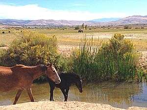
Along Steamboat Creek of the Truckee Meadow, the most common plants, include lush grasses like the Great Basin wild rye (Leymus cinereus) and tule (Scirpus sp.). Riparian vegetation of the meadow include black cottonwood (Populus trichocarpa), willow species (Salis sp.), and silver buffaloberry (Shepherdia argentea). At elevated and better-drained valley margins grows the typical sagebrush-grass zone. Common plants in this habitat consisted of big sagebrush (Artemisia tridentate), rabbitbrush (chrysothamnus sp.), greasewood (Sarcobatus vermiculatus), horsebrush (Tetradymia glabrata), and spiny hopsage (Grayia spinosa) Common bunch grasses included wheatgrass (Agropyron spicatum), bluegrass (Poa sp.), Great Basin Wild rye (Elymus cinereaus), Indian ricegrass (Achnatherum hymenoides), squirreltail (Sitanion hystrix), and needle and thread (Stipa comate).[4]
History
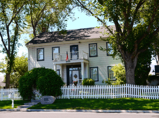
1857 pioneer rancher Peleg Brown, a Rhode Island native arrived in the Truckee Meadows with his brother, Joshua. The two brothers introduced alfalfa to the area and built their home (Damonte Ranch House) 150 years ago which still stands today. The house is listed on the National Register of Historic Places, which caused the Nevada Department of Transportation to divert the construction of U.S. Highway 395 freeway around the property to preserve the home and ranch.[5]
Geology
The Truckee Meadows is a valley in western Nevada located within the western Great Basin. Named for the Truckee River, which flows through the valley from west to east, this area contains archaeological evidence of aboriginal human occupation.[4]
The Truckee Formation, is the oldest deposit of the valley and yields very little water to wells. Most of the discharge of water is by evapotranspiration and by seepage to ditches and streams. Some water in the area is unsuitable for many uses because of its poor chemical quality. Water in the Steamboat Springs area is hot and has high concentrations of chloride and dissolved solids. Both water draining areas of bleached rock and ground water from areas of leached rock have high concentrations of sulfate and dissolved solids.[1]
References
- 1 2 3 Cohen, Philip (September 1, 2016). "USGS" (PDF). Evaluation of hydrogeology and hydrogeochemistry of Truckee Meadows area, Washoe County, Nevada. USGS Publications Warehouse. Retrieved 2016-08-21.
- ↑ Elfelt, Joseph. "Gmap4 = Enhanced Google Maps + GIS Viewer". Gmap4 from MappingSupport.com. Retrieved 2016-09-02.
- ↑ "Map Produced By Gmap4 | Enhanced Google Map Viewer". mappingsupport.com. Retrieved 2016-09-02.
- 1 2 3 Sibley, Krisstin (2013-11-08). "PREHISTORIC OBSIDIAN USE IN THE TRUCKEE MEADOWS AND ITS IMPLICATIONS FOR SETTLEMENT PATTERNS ALONG THE SIERRAN FRONT" (PDF). Members Peak. Department of Anthropology California State University, Sacramento. Retrieved 2016-09-01.
- ↑ "Damonte Ranch House marks 150 years". Retrieved 2016-09-03.