Tsirku River
| Tsirku River | |
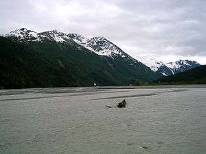 Tsirku River west of the mouth | |
| Country | United States |
|---|---|
| State | Alaska |
| Borough | Haines |
| Source | Tsirku Glacier |
| - location | north slope of Takhinsha Mountains |
| - elevation | 1,460 ft (445 m) [1] |
| - coordinates | 59°17′50″N 136°24′55″W / 59.29722°N 136.41528°W [2] |
| Mouth | Chilkat River |
| - location | Klukwan, 21 miles (34 km) southwest of Skagway, St. Elias Mountains |
| - elevation | 56 ft (17 m) [2] |
| - coordinates | 59°23′26″N 135°52′12″W / 59.39056°N 135.87000°WCoordinates: 59°23′26″N 135°52′12″W / 59.39056°N 135.87000°W [2] |
| Length | 25 mi (40 km) [3] |
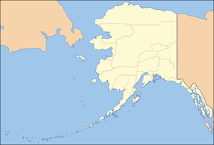 Location of the mouth of the Tsirku River in Alaska
| |
The Tsirku River is a glacier-fed stream in Southeast Alaska near the town of Haines in the U.S. state of Alaska. The river's source is found at the Tsirku Glacier, a large, sprawling ice mass at the border of Alaska and the Canadian province of British Columbia. The river ends in a 4-mile (6 km) wide delta near the Tlingit village of Klukwan. While many of the feeding glaciers are primarily in British Columbia, the river course lies entirely in Alaska.
After the Klehini River, the Tsirku River is the second largest tributary of the Chilkat River.
See also
References
- ↑ Derived by entering source coordinates in Google Earth.
- 1 2 3 "Tsirku River". Geographic Names Information System. United States Geological Survey. January 1, 2000. Retrieved January 1, 2014.
- ↑ Orth, Donald J.; United States Geological Survey (1971) [1967]. Dictionary of Alaska Place Names: Geological Survey Professional Paper 567 (PDF). United States Government Printing Office. p. 988. Retrieved January 1, 2014.
This article is issued from Wikipedia - version of the 9/10/2016. The text is available under the Creative Commons Attribution/Share Alike but additional terms may apply for the media files.